Showing 1-10 of 78 results

Sort By:

An Accurate Map of the Holy Land Divided into the XII Tribes of Israel. Accomodated to Sacred History & describing the Travels of Jesus Christ by Eman. Bowen.
Creator:
Publisher:
Date/Date Range Produced: 1752
Language:
Region Depicted:
Map Type:
Dimensions: H 41.1 X W 28.1 cm
Printing Process:
Material Type:
LC Call Number: G7500 .B6 1752
OCLC: 138109551
Accession Number: SM-1752-8
Donor:
Subjects:
Image Number:


Eretz Israel
Eretz Israel
Creator:
Date/Date Range Produced: 1527
Language:
Region Depicted:
Map Type:
Dimensions: H 30.4 X W 19.6 cm
Historical Context: One of the earliest Hebrew printed maps of the Holy Land published in the “Perush Rashi” in Venice in 1527. This book (and map) were created by Rabbi Mizrachi, but was not published until after his death in 1525-26. The map is based on places mentioned in the Hebrew Bible. It represents the Holy Land as an abstract, schematic image with east at the top and the land of Israel (Eretz Israel) in the center.
Accession Number: OS-1523-1
Donor:
Subjects:
Image Number:


Terra sancta a Petro Laicstain perlustrata, et ab cius ore et schedis a Christiano Schrot in tabulam redacta.
Creator:
Publisher:
Date/Date Range Produced: 1603
Language:
Region Depicted:
Map Type:
Dimensions: 37 x 51 cm on sheet 49.2 x 50.2 cm
Printing Process:
Material Type:
Historical Context: Depicts three scenes from the life of Christ and a scene from Jonah.
LC Call Number: G7481.3 .S3 1603
OCLC: 58437053
Accession Number: SM-1603-3
Donor:
Subjects:
Image Number:


Typvs Chorographicvs, Celebrivm Locorvm in Regno Ivdae et Israhel. arte factus a Tilemanno Stella Sigenensi.
Creator:
Date/Date Range Produced: 1586
Language:
Region Depicted:
Map Type:
Dimensions: 36 x 46 cm. on sheet 47 x 57 cm.
Printing Process:
Material Type:
LC Call Number: G7481.2 1601 S7
OCLC: 39107315
Accession Number: OS-1601-4
Donor:
Subjects:
Image Number:


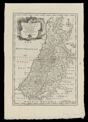
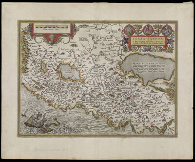
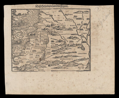
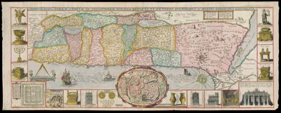
Terra Sancta a Petro Laicstain perlustrata, et ab eius ore et Schedis a Christiano Schrot in tabulam redacta
Creator:
Atlas Reference:
Date/Date Range Produced: 1584
Language:
Region Depicted:
Map Type:
Dimensions: 37 x 51 cm. on sheet 46 x 58 cm.
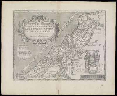
Printing Process:
Material Type:
Historical Context: The map was designed by Sgrooten based on geographical research of Peter Laicksteen (Laicstain-Liestain), a Dutch astronomer who had published a book in 1566 on his observations from his recent travels to the Holy Land. Map date based on the last line of Latin text in italic, "cium exequatur. Per Christum Dominum nostrum, Amen." (Koeman's 31:030)--cf. Van den Broecke. The map is from the Ortelius 1584 edition of the Theatrum orbis terrarum printed in Antwerp by Christopher Plantin, and was the first printing of the map which appears in all editions until 1612. It illustrated how the Holy Land would appear for one approaching by ship, which was the normal mode of travel for pilgrims.
LC Call Number: G7500 1584 .S56
OCLC: 80696384
Accession Number: OML-1584-6
Image Number:


Palestina Antiqua
Palestina Antiqua
Atlas Reference:
Printmaker:
Publisher:
Date/Date Range Produced: 1822
Language:
Region Depicted:
Map Type:
Dimensions:  H 26.8 X W 20.8 cm
Material Type:
Historical Context: The Hebrews divided Canaan among the twelve tribes which were eventually unified into a single Hebrew Kingdom, ca. 1000 bce . In this nineteenth century historical reconstruction, the political and tribal divisions are outlined in color. The tribal names are highlighted in red.
Accession Number: SM-1822-16
Donor:
Image Number:


Judaeae seu Terrae Israelis Tabula Geographica
Creator:
Date/Date Range Produced: 1680
Language:
Region Depicted:
Map Type:
Printing Process:
Material Type:
Accession Number: OML-1680-16
Donor:
Subjects:
Image Number:


Palestinae Sive Totivs Terrae Promissionis Nova Descriptio Avctore Tilemanno Stella Sigeneus
Creator:
Atlas Reference:
Date/Date Range Produced: 1579
Language:
Region Depicted:
Map Type:
Dimensions: 35 x 45 cm
Printing Process:
Material Type:
OCLC: 682935121
Accession Number: OML-1579-7
Donor:
Image Number:


Des Gelobtenlandte Figur.
Creator:
Date/Date Range Produced: 1586
Language:
Region Depicted:
Map Type:
Dimensions: 12 x 16 cm.
Printing Process:
Material Type:
LC Call Number: G7501.S4 S7 1586
OCLC: 905854836
Accession Number: OS-1586-1
Donor:
Subjects:
Image Number: