Showing 51-60 of 78 results

Sort By:

Guerre d'orient carte dressee d'apres les documents les plus authentiques pour les abonnes du Pilote du Cavaldos
Publisher:
Language:
Region Depicted:
Dimensions: 40 x 54 cm on sheet 50 x 65 cm
LC Call Number: G7001.S54 1854 M5
OCLC: 1102680209
Accession Number: OS-1854-66
Donor:
Image Number:


War in the Holy Land : from Meggido to the West Bank
Author:
Date Produced: 1998
Language:
Dimensions: Height: 27
Physical Description: 1book: xii, 212 pages, illustrations (some color), colored maps
LC Call Number: DS119.2 .D85 1998
OCLC: 40222060
Accession Number: OS-1998-1
Donor:
Image Number:


The Holy Land as allotted by Joshua to the Twelve Tribes of Israel
Content:
Language:
Region Depicted:
Image Number:


A New Map of the Land of Promise and the Holy City of Jerusalem
Creator:
Date/Date Range Produced: 1828
Language:
Dimensions: 105 x 125
Accession Number: OML-1828-26
Image Number:


Reader's digest Atlas of the Bible : an illustrated guide to the Holy Land
Date Produced: 1991
LC Call Number: BS635.2 .R4
OCLC: 7966355
Accession Number: GIB-1991-16
Donor:
Image Number:


Reader's digest Atlas of the Bible : an illustrated guide to the Holy Land
Date Produced: 1983
LC Call Number: BS635.2 .R4
OCLC: 7966355
Accession Number: GIB-1981-767
Donor:
Image Number:


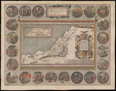
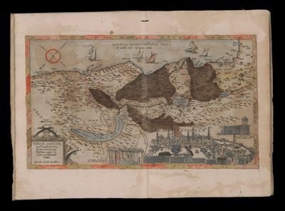
Abrahami Patriarchae Peregrinatio, et Vita. Abrahamo Ortelio Antverpiano auctore.
Creator:
Atlas Reference:
Dedicatee:
Publisher:
Date/Date Range Produced: 1586
Language:
Region Depicted:
Map Type:
Dimensions: H 39 x W 50 cm
Printing Process:
Material Type:
Historical Context: This map is an acknowledged masterpiece of composition and engraving by the great Flemish cartographer, Abraham Ortelius; it illustrates the Biblical story of Abraham the Patriarch as recorded in Genesis. The Hebrew peoples were originally nomadic. Their origins lie with the Patriarch Abraham and his migration from Mesopotamia to the Promised Land of Canaan, where his followers and descendants settled. The decorative border contains twenty-two medallions portraying scenes from the life of Abraham, such as the sacrifice of Isaac. The central portion is in the form of a tapestry containing two maps. The small inset map at upper left traces Abraham's wanderings from Ur in the Euphrates Valley to the Promised Land of Canaan; several cities are named, the most prominent of which is Salem, the future Jerusalem. The larger map depicts the ancient tribal divisions of the Land of Canaan as described in Genesis; the largest city, as judged by its symbolic representation, is named "Salem, et Ierusalem."
LC Call Number: G7481.2 1608 .O7
OCLC: 819752711
Accession Number: OS-1608-2
Donor:
Image Number: