Showing 51-60 of 83 results

Sort By:

Polar regions. Greenland. Antarctic regions.
Creator:
Date Published: 1847
Publisher:
Language:
Dimensions: 17 x 11.5 cm
Image Number:


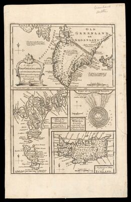
A Map of Old Greenland or Østerbygd & Westerbygd, agreeable to Egede's late Description of Greenland. by Eman. Bowen.
Creator:
Date/Date Range Produced: 1752
Language:
Dimensions: 13 x 22 cm, 18 x 12 cm, 9 x 10 cm, and 9 x 13 cm, on sheet 46 x 59 cm
Accession Number: OML-1752-1
Image Number:


An Arctic outpost : The Greeley Expedition in Discovery Harbor, Greenland.
Date/Date Range Produced: 1882
Language:
Dimensions: H 39.9 x W 27.8 cm
LC Call Number: G3270 .H3 1882
OCLC: 77486922
Accession Number: OS-1882-15
Donor:
Image Number:


Denmark for 20,000 years
Creator:
Publisher:
Language:
Map Type:
Dimensions: 84 x 106 cm
LC Call Number: G6916.A5 1969 .A27
OCLC: 4788343
Accession Number: OS-1969-178
Donor:
Donation Date: Oct 26th, 2021
Subjects:
Image Number:


Index to the National Geographic Society's map of Canada, Alaska, and Greenland.
Publisher:
Date Produced: 1947
Language:
LC Call Number: G3400 1947 .N3 Index
OCLC: 182891954
Accession Number: OS-1947-119
Donor:
Donation Date: Mar 1st, 1999
Image Number:


The Coast of Northeast Greenland -Plates- [Slipcase containing 12 sheets]
Author:
Date Produced: 1948
Language:
Dimensions: 26 x 17
LC Call Number: G743.B59 1948
OCLC: 1179487
Accession Number: OML-1948-55
Image Number: