

Collection: Osher Collection
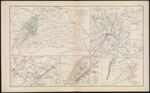
Name: Map of Orange County &c., VA. embracing the details and plans of operations of Confederate and Federal forces at Mine Run and Rapidan River
Barcode:
Image Number:
Creator:
Date Created:
Date Published:
Alternative Title: Part of map of portions of the military departments of Washington, Pennsylvania, Annapolis and Northeastern Virginia; [Map 3: Position of the Army of the Tennessee, near Atlanta, GA., July 22, 1864]; [Map 4: Vicinity of Browning's Court-House, GA., July, 1864]; [Map 5: Region about Sandtown Ferry, GA., July 5, 1864]; Map to show lines of march of Second Army Corps and the enemy Oct. 14, 1863.; Map of Battle-Field at Bristoe fought by 2d Army Corps commanded by Maj. Gen. G. K. Warren October 14 1863.; Map of Missionary Ridge, Tenn. showing the positions attacked by the forces under the command of Maj. Gen. W. T. Sherman Nov. 24th and 25th 1863.
Notes: "July" "October 14th" "November 24th" "November 25th" 1861 - Inscribed on Map; 1863 - Inscribed on Map
Permanent URL: