

↑ Parent: Atlas Accompanying Greenleaf's Map and Statistical Survey of Maine
Collection: Osher Collection
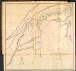
Name: Sketch from Bouchette's maps of upper & lower Canada and the District of Gaspe Exhibiting the true range of Highlands dividing the waters of the St. Lawrence & the Atlantic, a[nd th]e imaginary ranges claimed by the British for the boundary of th[e Sta]te of Maine.
Barcode:
Image Number:
Creator:
Date Created:
Date Published:
Printing Technique:
Subjects:
Permanent URL: