

Collection: Osher Collection
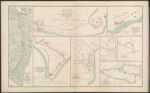
Name: Department of Cape Fear. Maj. Gen. W. H. C. Whiting, commanding. Section of map of parts of Brunswick and New Hanover Counties. Showing the approaches to Wilmington, N. C.
Barcode:
Image Number:
Creator:
Date Created:
Date Published:
Alternative Title: North Atlantic Squadron, Rear-Admiral D. D. Porter, com'd'g. Fort Caswell and adjoining works at Western Bar Cape Fear River, N. C. evacuated Jan. 16th, 1865. Taken possession of by the naval and military forces Jan. 17th, 1865.; North Atlantic Squadron, Rear-Admiral D. D. Porter, com'd'g. Fort Johnston, Smithville, N.C. evacuated January 16th, 1865. Taken possession of by the naval and military forces, Jan. 17th, 1865.; North Atlantic Squadron, Rear-Admiral D. D. Porter, commanding. Line of rebel works, Smith's Island, N. C. evacuated Jan. 16th, 1865. Taken possession of by the naval and military forces, Jan. 17th, 1865.; Defenses of Augusta, GA. from original in possession of Gen. Braxton Bragg, C. S. Army; Augusta, GA., 1864.; Plan of the fortifications at Columbus, GA, 1864.; Map of the Battle-Field of Champion's Hill, Miss., May 16, 1863.
Notes: "February 13, 1865." "January 16, 1865." "January 17, 1865." "May 16, 1863." 1865 - Inscribed on Map; 1864 - Inscribed on Map; 1863 - Inscribed on Map
Permanent URL: