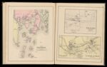
Map of Boothbay and adjacent islands. Drawn from U.S. coast survey charts. / Freeport Village, Cumberland Co. / Saccarappa & Cumberland Mills, Cumberland County.
↑ Parent: Colby's Atlas of the State of Maine : including statistics and description of its history, educational system, geology, railroads, natural resources, summer resorts and manufacturing interests compiled and drawn from official plans and actual surveys and published by Colby & Stuart
Collection:
Osher Collection
Name: Map of Boothbay and adjacent islands. Drawn from U.S. coast survey charts. / Freeport Village, Cumberland Co. / Saccarappa & Cumberland Mills, Cumberland County.
Barcode: 3749
Image Number: 3749.0018
Creator: Colby & Stuart
Printmaker: Bourquin, Fredrick & Co.Bracher, Wm. (William)
Date Published: 1887
Full Title: Map of Boothbay and adjacent islands. Drawn from U.S. coast survey charts. / Freeport Village, Cumberland Co. / Saccarappa & Cumberland Mills, Cumberland County.
Publisher: Colby & Stuart
Language: English
Permanent URL:
https://oshermaps.org/map/3749.0018