

Collection: Smith Collection
Name: An Accurate Map of North America. Describing and distinguishing the British and Spanish Dominions on this great Continent; According to the Definitive Treaty Concluded at Paris 10th Feb. Y 1763
Barcode:
Image Number:
Creator:
Printmaker:
Date Published: 1775
Content:
Subjects:
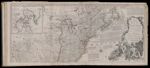
Full Title: An Accurate Map of North America. Describing and distinguishing the British and Spanish Dominions on this great Continent; According to the Definitive Treaty Concluded at Paris 10th Feb. Y 1763 - Also all the West India Islands belonging to, and possessed by the Seceral European Princes and States. The whole laid down according to the latest and Most authentic Improvements, By Eman Bowen Geogr. to His Majesty and John Gibson Engraver.
Surveyor:
Publisher:
Language:
Region Depicted:
Dimensions: Map: H 50.5 x W 116 cm on sheet: H 54.5 x W 121 cm
Printing Process:
Printing Technique:
Permanent URL: