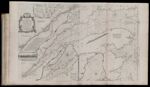
An Exact Chart of the River St. Laurence, from Fort Frontenac to the Island of Anticosti shewing the Soundings, Rocks, Shoals &c. with Views of the Lands and all necessary Instructions for navigating that River to Quebec...
↑ Parent: The American atlas or, A geographical description of the whole continent of America. Wherein are delineated at large, its several regions, countries, states, and islands and chiefly the British colonies. Engraved on 48 copper-plates, by Thomas Jefferys and others
Collection:
Smith Collection
Name: An Exact Chart of the River St. Laurence, from Fort Frontenac to the Island of Anticosti shewing the Soundings, Rocks, Shoals &c. with Views of the Lands and all necessary Instructions for navigating that River to Quebec...
Barcode: 1986
Image Number: 1986.0031
Creator: Jefferys, Thomas, 1710-1771
Date Published: May 25th, 1775
Content: Graphic
Subjects: Navigation
Full Title: An Exact Chart of the River St. Laurence, from Fort Frontenac to the Island of Anticosti shewing the Soundings, Rocks, Shoals &c. with Views of the Lands and all necessary Instructions for navigating that River to Quebec...
Publisher: Robert Sayer and John Bennett (Firm)
Language: English
Region Depicted: Atlantic Coast (North America)Labrador, CanadaNew EnglandNova ScotiaQuébec, CanadaSt. Lawrence River
Dimensions: Map: H 59.5 x W 94.5 cm on sheet: H 64.5 x W 107.5
Printing Process: Engraving
Printing Technique: Copper
Permanent URL:
https://oshermaps.org/map/1986.0031