Donations comprise the majority of our collections. Beyond our two founding collections, donated by the Smith and Osher families, many of our maps, globes, atlases, books, and other map-related ephemera have been generously given to us by other longtime donors, as well as one-time donations from long-time patrons or first-time visitors. These donations make our preservation and education outreach work possible, and are always greatly appreciated. Not only do these gifts help us fulfill our mission by preserving and sharing the cartographic heritage of our region and the world beyond, researching the context of these items often reveals interesting new stories.
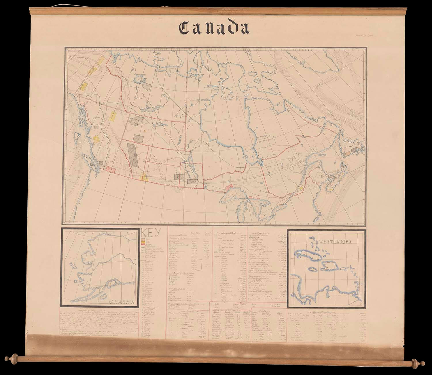
This hand-drawn wall map by Margaret M. Harris, a young teacher, was among three maps generously donated in 2019 by Linda B. Holmberg after she and her family found them in the basement of a family home in Bear River, Nova Scotia. At the time we received this donation, we were well under way with the preparations for our fall/winter 2019-2020 exhibition, "Mapping the Classroom: Teaching Geography and History in 19th and 20th Century New England." This large manuscript map quickly stood out as an item that was likely made for classroom use. The Margaret M. Harris manuscript map of Canada is a wonderful addition to our collections, given our special interest in maps made by school children and teachers in the late-nineteenth and early-twentieth centuries. Harris's map, created circa 1903, is the first Canadian school map in our collections.
We were also able to narrow down the estimated date of creation. This manuscript map was one of three included the donation. The accompanying items were also large wall maps, including a 1904 "New Quick Reference Map of the Dominion of Canada" and the 1904 "Survey of the Western and Eastern Part of the Dominions." Although Margaret's map is not dated, there are a number of statistics listed at the bottom, such as population, revenue, and postal statistics. Looking at the population data for Canada in the early 1900's, there is not an exact match for the number she lists: 5,338, 883.

One issue we faced is that statistical data varies depending on the source, but the population of Canada recorded on the 1901 census is listed as 5,371,315. The population of Nova Scotia from the same record is listed as 459,574; this is a little more than the number written on the map (459,523), but it is incredibly close. The population statistics do not exactly pinpoint a year, but they do determine that our first dating estimates were in the right time frame.
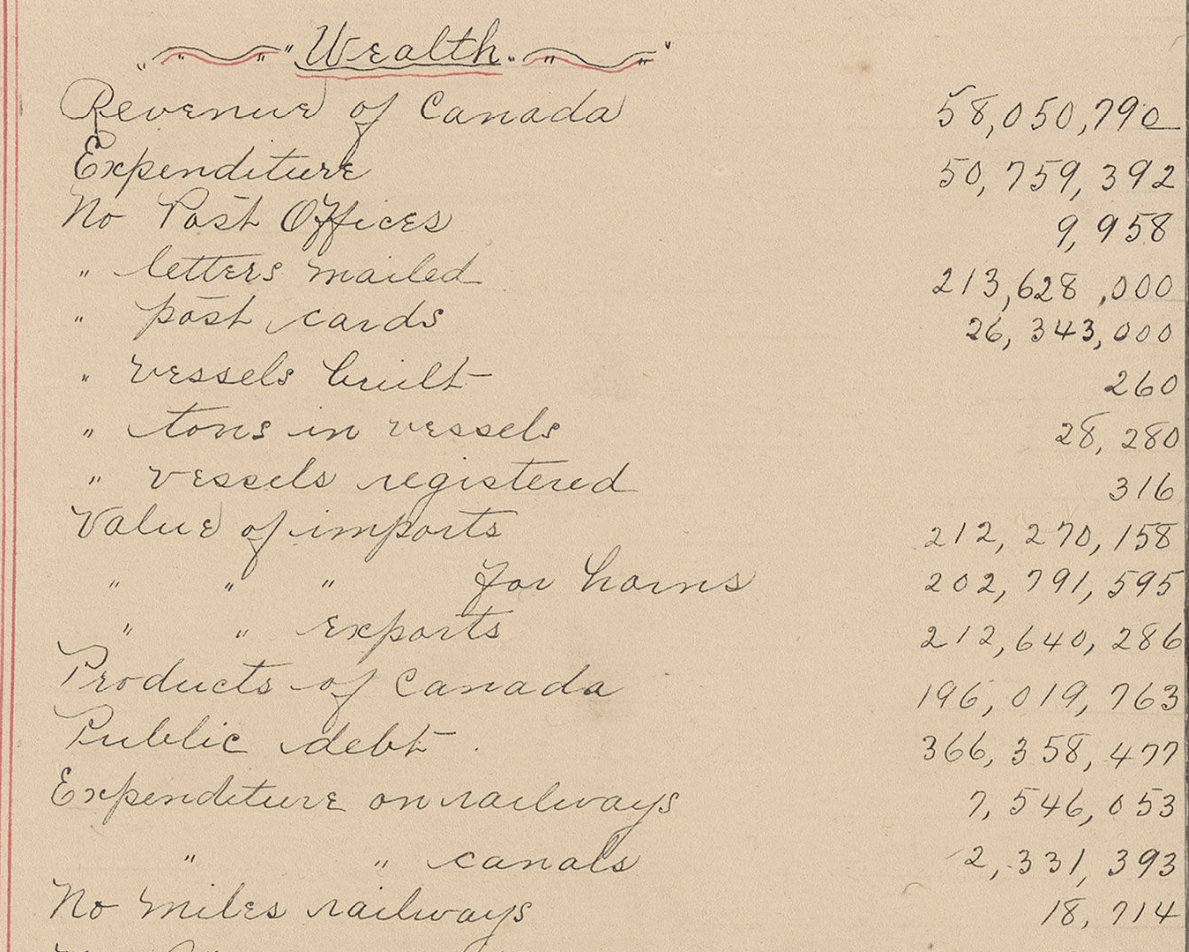
Nevertheless, Harris provided a plethora of other statistics on her wall map, including those related to the "Wealth" of Canada. We were able to compare these statistics to those in the Statistical Year Book of Canada to help narrow down the date of creation.
The Statistical Year Book of Canada for 1903, Volume 19 (published 1904) is a large tome that provides many statistics for Canada and its provinces covering the years of 1886-1903. A number of the statistics for the year 1902 match what is listed on Harris's map. For instance, the book lists the Revenue of Canada for the year ending June 30, 1902 matches what is written on the map: 58,050,790. Other statistics on the map match for the year 1902, such as the number of post offices (9,958), letters mailed (213,628,000), and postcards (26,343,000). Thus, we can assume that this map was created after June 30, 1902, and likely before the end of the next fiscal year, June 30, 1903. Like many students and teachers who made maps, it is quite possible that Harris got her data from a variety of sources before synthesizing it on her map.
One question that always stands out when looking at a map is "Who made this?" and, equally as important, "Why?"
We knew that the creator of the map was a Margaret M. Harris, as stated on the upper right hand corner of the map. Additionally, it was likely that she was from or lived in Bear River, Nova Scotia at some point in her life.
A foray into the archives of Nova Scotia revealed that there was a Margaret May Harris born in Bear River, Nova Scotia, on September 20, 1884. Further searching produced an Annual report of the Superintendent of Education on the Public Schools of Nova Scotia for the year 1905, within which Margaret May Harris was listed as a graduate of the Provincial Normal School in Truro in the first rank. Normal Schools, in both the United States and Canada, were popular sites for post-secondary teacher education throughout the late-nineteenth and early-twentieth centuries. At our request, the Little White Schoolhouse Museum in Truro, Nova Scotia, connected with the Provincial Normal School of the same town, did a thorough search of their records and found that Harris was a member of the class of 1904-05 when she was twenty years old, attending from October 1904 to June 1905 in the "B" Class. She was 20 years old in 1904, and had two years of teaching experience prior to attending the Normal School. Upon graduation in 1905, she was awarded the Diploma of First Rank.
They were also able to find a picture of Miss Harris' class, she can be found in the center of the top row.
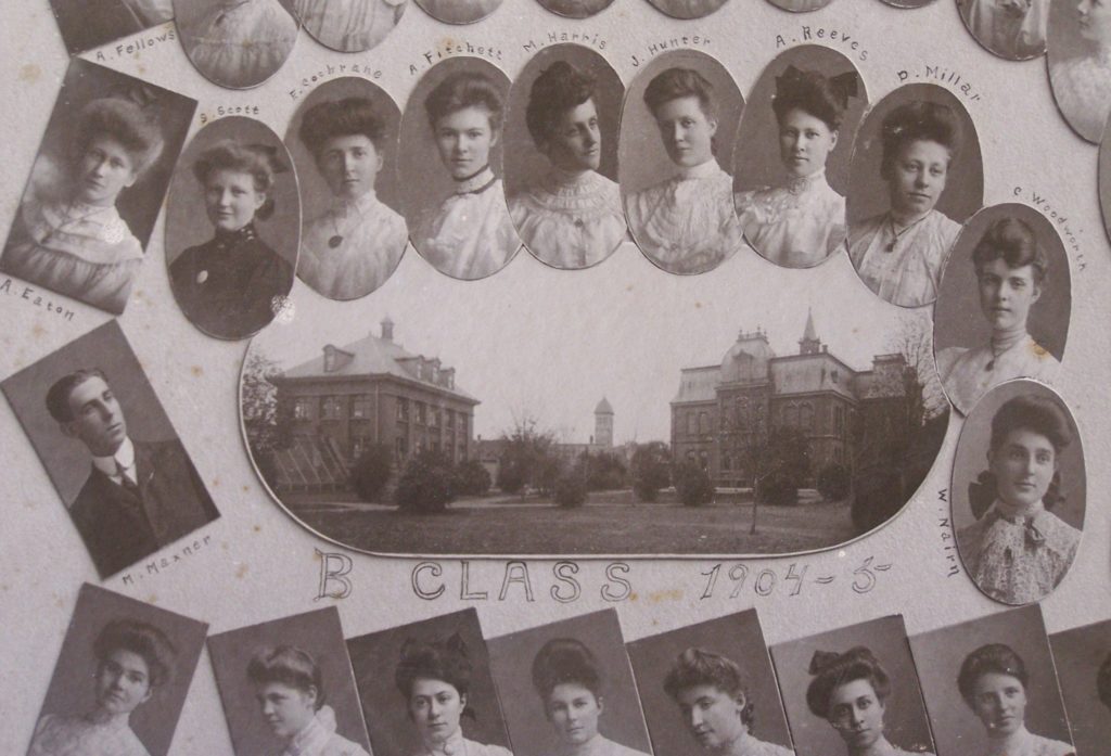 Courtesy of the Little White Schoolhouse Museum
It is rare to find an image of one of the students or teachers who made these manuscript maps. To be able to put a face to a name and know some of her history is a unique experience.
As for the map itself, the Little White Schoolhouse Museum said that they do "have a couple of geography projects completed by students at the Normal School. These projects are handmade books on the geography of the town of Truro, NS, with maps of the area, notes on history and local industry, not large maps like [this] one." - Melanie Ballard, Volunteer Curator of the Little White Schoolhouse Association.
Knowing the date the map was likely made (circa 1902-1903), the dates Margaret May Harris attended the Provincial Normal School (1904-1905), and the fact that this kind of project is not wholly similar to other projects from the school, it is fair to deduce that this map was made before Miss Harris attended the Normal School, likely during the two years of teaching experience mentioned above.
To further support this theory, we found a "Miss Harris" mentioned in both the 1902 and 1903 Annual Reports of the Superintendent of Education on the Public Schools of Nova Scotia. Included in these reports are the meeting notes from the Teacher's Institutes in each county. At these institutes, teachers and administrators from throughout the county came to present on and discuss issues such as teaching methods, textbooks, and policies for their county. The mention of "Miss Harris" in the 1902 report is particularly interesting. On page 207 in the report of the schools of Annapolis and Digby County they recount the presentations given at the Instituted, including one given by Miss Harris:
"Miss Harris showed how she taught the Geography of Annapolis and vicinity, having ample illustrations of bays, capes, watersheds, etc., at hand, and from this she found pupils eager to learn the Geography of the rest of the country."
Given the large size of this wall map, measuring 113 x 122 cm (approximately 44.5 x 48 in), and the detailed and interactive way she taught geography, it is easy to imagine the map now in our collections was used as a teaching tool for Miss Harris' classroom.
Margaret May Harris, born September 20th, 1886, applied for American citizenship on January 16th, 1923 in Boston, Massachusetts. Her application notes that she emigrated from Yarmouth, Nova Scotia, to Boston, Massachusetts, around July 1905. This would have been shortly after her graduation from the Provincial Normal School in June of 1905.
The 1910 United States Census includes a record of a Margaret M. Harris, age 25, born in Canada, as an employee of the Hillside School in Greenwich, Massachusetts. The Hillside School was founded in 1901 by two sisters, Charlotte Drinkwater, and Mary Drinkwater Warren, as a place for homeless and disadvantaged children. Photos of the school from around 1910 can be found here, through the University of Massachusetts.
There is also a likely match for Margaret M. Harris on the 1920 United States Census, a 35 year old teacher and lodger in Brookline, Massachusetts. The same Margaret M. Harris is listed at the same address in the 1922 Directory of Brookline, Massachusetts. At this point, it becomes harder to track Miss Harris, though it seems likely she continued on her path as a bright, engaging educator.
Many thanks to the Friends of the Little White Schoolhouse Association at the Little White Schoolhouse Museum in Truro, Nova Scotia, especially Melanie Ballard, the Volunteer Curator. https://littlewhiteschool.ca/