Exhibit Introduction:
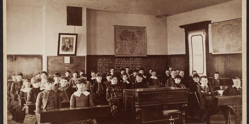
“Mapping the Classroom” examines the ways in which the young men and women of New England were taught the subjects of History and Geography in the nineteenth and twentieth centuries by bringing visitors into the classrooms of the era through photographs, teaching aids, textbooks, classroom maps and globes, games, and work created by students.
The Massachusetts Bay Colony enacted a law in 1647 that mandated towns of fifty families or more hire a schoolmaster who would teach children to read and write. Towns of a hundred families had to employ a grammar schoolmaster who could prepare male children to attend Harvard College (founded in 1636, a year after the nation’s first public high school, Boston Latin, was founded). This was a shift from a 1642 law that mandated parents and guardians responsible for their child’s literacy and education. New England colonies, and later, New England states, took the education of their youth very seriously, and in many ways led the nation in a variety of educational reform movements throughout the nineteenth century.
Throughout the colonial era, a variety of educational institutions took shape, including local “Dame Schools,” where women taught young children to read and write in their homes. After the Revolutionary War, academies and seminaries aimed at the secondary education of young men and young women sprung up all over New England. Public education soon followed, in fits and starts. By 1870, all states had publicly subsidized elementary schools, but elementary school completion was not compulsory throughout the United States until 1913.
It is important to remember that throughout the Colonial era and into the early Republic, schools were most accessible to young white men, and then, beginning in the eighteenth century, to young white women from families of some wealth and stature. Education throughout the thirteen colonies and later the United States was in no way uniform and was shaped by local beliefs and practices, as well as race, gender, economics, religion, and social class. Equal access to education remains a central issue in the modern era, and the teaching of History and Geography should remain a key aspect of a student’s educational experience.
Excerpt from Virtue Howard’s prize-winning “Essay on the best methods of teaching Geography,” from the Oxford [Maine] Democrat, April 8th, 1870.
“Geography and history should be inseparable companions. After reciting the lesson, I often employ some one of the class to take the map pointer and in selecting different places, I connect them with fragments of history: for instance, the island of St. Helena, with Napoleon Bonaparte, Juan Fernandes, with Alexander Selkirk, &c. Something of the novel and marvelous should be connected to render them forcibly presented to the mind.
Another method I have practised, of having the pupils draw on their slates or Black Board, the outlines of some prominent features of the earth; to make a map of your own town, and then attach the neighboring ones, is a very fine idea. Recently I have taken even my alphabet class, and having taught them the town, County and State, drawn them into a little geography class, by pointing out and naming the mountains, rivers, islands, valleys, peninsulas, &c., all within their own views and when possible, take a little walk with them and render it as pleasant as possible by chatting in a very familiar manner. It has wonderfully pleased my little charges, and has well paid me for my toil; but I have always tried to render it romantic.
As I often witness with regret that many of my older pupils leave the study of Geography when they ought not, and having no history in many schools, I devised a method of giving out one or two questions to be remembered by all the capable years, to be reported the next morning. I commenced with the creation; and from period to period, bringing it to our own time, until from time to time with geography; thus I have what I call a general class, from the oldest even to the youngest pupil connected.”
Acknowledgements
This exhibition was curated by Libby Bischof, Executive Director of the Osher Map Library and Smith Center for Cartographic Education, and Professor of History at the University of Southern Maine. I wish to thank the entire staff of the map library for all of their assistance with researching, cataloguing, processing, and digitizing the items in the exhibition, and for their tireless teamwork and stewardship of the library and our collections. Thank you to Hope Mowry for preparing the exhibit guide. Special thanks to our preparator Kevin Callahan of Kimball Street Studios for framing the items and mounting the show. I am indebted to the research of historian Susan Schulten and decorative arts curator Laura Fecych Sprague for their pioneering work on schoolgirl art in New England and beyond.
We are grateful to the Maine Historical Society for loaning some of the stunning schoolgirl art from their collections to complement our holdings, and to James Arsenault of Arrowsic for the loan of the slate globe. Thanks also to USM Special Collections, the Brick Store Museum, the Pejepscot Historical Society, and Historic New England for granting permission to use photographic images from their collections throughout the exhibitions.
This exhibit is dedicated to the memory of Peggy Osher and Eleanor Huston Smith, founding patrons of the Osher Map Library and Smith Center for Cartographic Education, in honor and recognition of their strong belief in educational outreach through geography, history, and art. We are deeply grateful for their vision and for their many years of support.