
13. Bauer, Carl, 1825 The world with its inhabitants Smith Collection: SM-1825-9 https://oshermaps.org/map/2367.0001 This little educational toy is a miniature globe only two inches in diameter. It is accompanied by an unfolding paper featuring...
12. Unknown, 1910 [Zodiacal Globe] Smith Collection: SM-1910-35 www.oshermaps.org/map/2355.0001 The curious artwork on the case floor demonstrates how the constellation was a largely irrelevant concept by 1900. Astronomers used constellation...
11. Gilman Joslin, 1860 Joslin’s Six-Inch Terrestrial Globe Smith Collection: SM-1860-23 www.oshermaps.org/map/2344.0001 This globe demonstrates the changing of seasons, night and day, and eclipses, as the Earth orbits around the Sun, repr...
10. Geographia LTD., 1920s Geographia Six-Inch Terrestrial Globe Smith Collection: SM-1890-27 www.oshermaps.org/map/2350.0001 ...
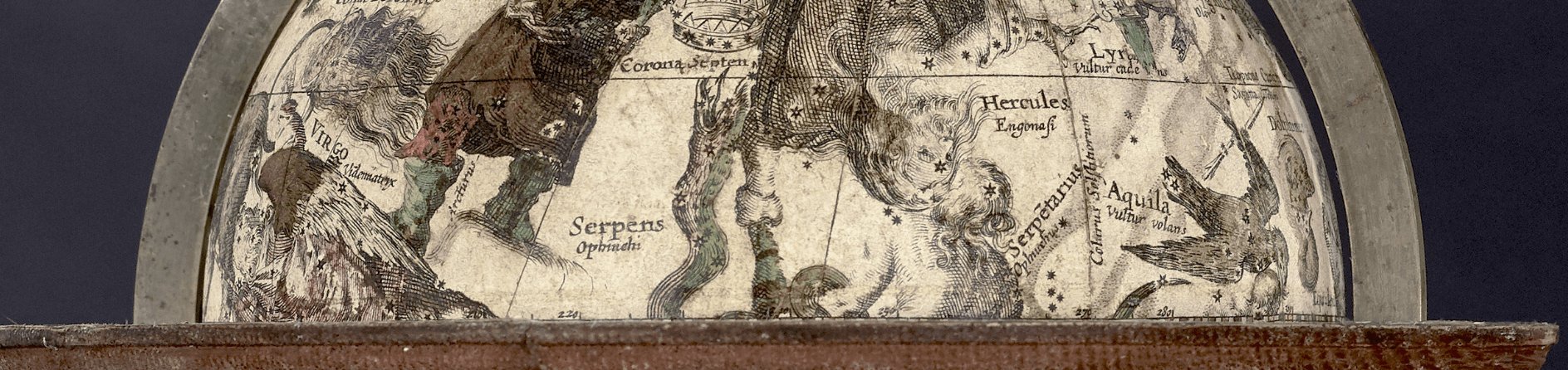
9. Willem Jansz (Blaeu), 1606 Sphaera Stellifera Accurate Smith Collection: SM-1855-69 www.oshermaps.org/map/2320.00001 Sphaera Stellifera Accurate (#9) is the oldest globe currently on display in our cases. It was created by Willem Jansz. B...
6. Josiah Loring, 1855 Loring’s Terrestrial Globe Smith Collection:SM-1855-69 www.oshermaps.org/map/49626.0001 Joslin was Loring's assistant and took over globe production, hence the discrepancy between title and creator...
4. Henry Bryant, 1872 The Celestial Indicator Osher Collection: OS-1872-21 www.oshermaps.org/map/13344.0001 This armillary sphere (#4) not only shows the lines of the Earth, but it also shows the movements of the solar system. All eight plan...
20. Charles Francois Delamarche, 1787 Globe Dresse par M. Robert De Vaugondy Smith Collection: SM-1787-8 www.oshermaps.org/map/2325.0001 This terrestrial globe, another product of Delamarche, was originally created by Robert de Vaugondy to vi...
1. Gabriel Wright, 1782 Wright’s New Improv’d Celestial Globe Smith Collection: SM-1782-6 www.oshermaps.org/map/2323.0001...
2. Ludwig J. Heymann, 1880 Erd-Globus Smith Collection: SM-1880-26 www.oshermaps.org/map/2348.0001...