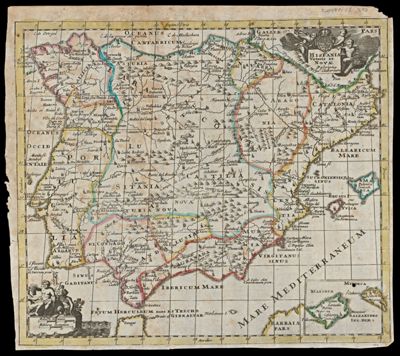
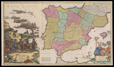
Weg-Wyzer der Legertogten in Spanje en Portugaal, door Abraham Allard te Amsterdam op den Dam : Theatrum Martis in Hispania, et Portugallia, Auctore Abrahamo Allard Amstelo-Batavo, cum priviligio
Creator: Allard, AbrahamPublisher: Allard, AbrahamDate/Date Range Produced: 1700
Language: DutchLatinRegion Depicted: Balearic IslandsIberian PeninsulaPortugalSpainMap Type: GeographicalPolitical mapsDimensions: 50 x 59 cm
Printing Process: EngravingMaterial Type: PaperHistorical Context: Although the Spanish Empire declined somewhat in political importance during the seventeenth century, it remained a powerful entity whose territories continued to provide important trading destinations. Many people throughout Europe, especially merchants and politicians, needed basic information about the location and extent of the empire's various territories. Dutch commercial cartographers provided this information in a variety of forms. Abraham Allard, for example, listed the Spanish and Portuguese possessions in a large block of text; he also named the ancient peoples (e.g., the Turditani of Badajoz) of the seventeen regions from which Spain and Portugal were formed.
LC Call Number: G6560 .A4 1700
OCLC: 71276537
Accession Number: ENG-1700-17
Donor: EnggassSubjects: Balearic IslandsIberian PeninsulaPortugalSpain