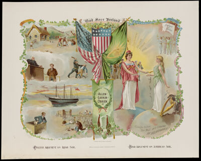
Osher Map Library Sheet Map Collection

4,694 results

The Story Map of the West Indies
Publisher:
Language:
Region Depicted:
Map Type:
Dimensions: H 32 x W 40 cm
LC Call Number: G4900.A5 1950 .C6
OCLC: 872330844
Accession Number: OML-1936-191
The Story Map of the West Indies

Exercier - Platz in Sans Souci auf Hayti
Date/Date Range Produced: 1813
Language:
Region Depicted:
Map Type:
Dimensions: 34 x 43 cm on sheet 43 x 53 cm
Printing Process:
LC Call Number: G4944.M38 1813 K8
OCLC: 1390649803
Accession Number: OML-1813-15
Exercier - Platz in Sans Souci auf Hayti

God Save Ireland
Creator:
Publisher:
Date/Date Range Produced: 1895
Language:
Region Depicted:
Dimensions: 59 cm x 73 cm.
Printing Process:
Material Type:
Historical Context: The broadside depicts Ireland in the throes of political and social turmoil brought on by harsh British rule and a series of natural disasters including the Famine of the 1840's. It is also a way to persuade the Irish to come to the United States for a better life as illustrated with the figures of Columbia handing Erin representing Ireland a sword for deliverance from the problems of the country. In the end thousands of Irish left for America to try and better their lives.
LC Call Number: DA955 1895.G3
OCLC: 1391238487
Accession Number: OML-1895-113
God Save Ireland

Pictorial lunar map
Creator:
Date/Date Range Produced: 1963
Language:
Map Type:
Dimensions: 87 cm x 85 cm
Material Type:
OCLC: 5474400
Accession Number: MO-1963-208
Donor:
Donation Date: Mar 7th, 2013
Pictorial lunar map

A general chart of the island of Newfoundland with the rocks & soundings by James Cook and Michael Lane, surveyors, and others.
Creator:
Publisher:
Date/Date Range Produced: 1775
Language:
Region Depicted:
Map Type:
Dimensions: 55 x 56 cm
LC Call Number: G3436 P5 1775.C6
OCLC: 425957764
Accession Number: OML-1775-33
A general chart of the island of Newfoundland with the rocks & soundings by James Cook and Michael Lane, surveyors, and others.

Medical Events in North America
Creator:
Date/Date Range Produced: 1950
Language:
Region Depicted:
Map Type:
Dimensions: 53cm x 77 cm
Historical Context: Map shows the progress of medicine and accomplishments in the field by numerous scientists of the late nineteenth and early twentieth centuries. Abbott Laboratories which used this as a promotion for its pharmaceuticals was founded in 1888 by Dr. Wallace C. Abbott of Chicago. During World War II it led an effort to ramp up production of penicillin. It continues to focus on a variety of general pharmaceuticals.
LC Call Number: G3301.E55 1950 C6
OCLC: 1393654741
Accession Number: OML-1950-245
Subjects:
Medical Events in North America

Map of the City of Portsmouth, New Hampshire
Creator:
Publisher:
Date/Date Range Produced: 1876
Language:
Region Depicted:
Map Type:
Dimensions: 127cm x 124 cm
OCLC: 1037493288
Accession Number: OML-1876-96
Donor:
Donation Date: Aug 8th, 2023
Map of the City of Portsmouth, New Hampshire

Print of the Cyclorama of the Battle of Gettysburg by Paul Philippoteaux
Publisher:
Date/Date Range Produced: 1885
Language:
Map Type:
Dimensions: 38 cm x 41 cm
Material Type:
Accession Number: OML-1885-83.2
Print of the Cyclorama of the Battle of Gettysburg by Paul Philippoteaux

State of Maine Catholic Churches and Missions
Creator:
Publisher:
Date/Date Range Produced: 1951
Language:
Region Depicted:
Map Type:
Dimensions: 79 x 51 cm on sheet 85 cm x 56 cm
Material Type:
LC Call Number: G3731.E42 1951 G7
OCLC: 1399970158
Accession Number: OML-1951-223
State of Maine Catholic Churches and Missions

Make good the promise : second war fund one hundred million dollars May 20th - 27th
Publisher:
Date/Date Range Produced: 1918
Language:
Dimensions: 143 cm x 89 cm
Printing Process:
LC Call Number: D522.25 M35 1918
OCLC: 651008728
Accession Number: OML-1918-129
Make good the promise : second war fund one hundred million dollars May 20th - 27th