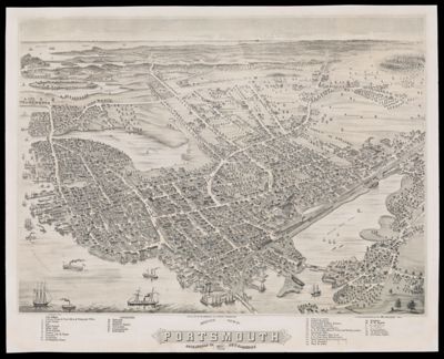
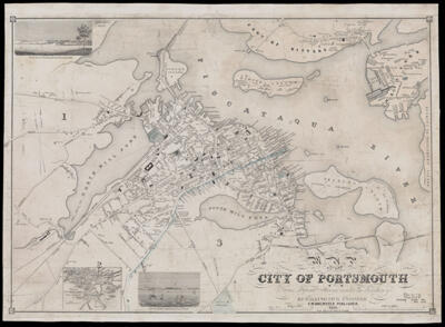
Map of the city of Portsmouth, N.H. from original surveys under the direction of H.F. Walling.
Publisher: Brewster, Charles WarrenSurveyor: Walling, Henry Francis, 1825-1888Language: EnglishRegion Depicted: Portsmouth, New HampshireMap Type: City mapsDimensions: 58 x 83 cm
Historical Context: Published in 1850, this large format map of the city of Portsmouth, New Hampshire, is among the earliest works of the Providence, Rhode Island-based surveyor, cartographer, and civil engineer Henry Francis Walling. In the 1850s, Walling became known for his highly detailed city and town plans and surveys, largely conducted in New England, before he moved his business to New York City in 1856. Walling worked closely with town officials on his plans, and, after producing a set number of maps for the cities and towns, sold additional copies himself. In addition to carefully labeled streets, residences, cemeteries, churches, libraries, and commercial endeavors, Walling's map of the city of Portsmouth includes two sketches: "Portsmouth Navy Yard from Central Wharf" and "River view of Portsmouth from Freeman's Point," as well as an "Inset sketch of Portsmouth Harbor from the best authorities." In 1850, this northern New England port city, population 9,738, was still heavily dependent on ship-building and maritime trade. A partial view of Kittery, Maine, including the Portsmouth Naval Ship Yard, is visible in the upper right hand corner of the map.
LC Call Number: G3744.P8 1850 W35
OCLC: 80928867
Accession Number: OML-1850-56