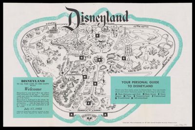
Osher Map Library Sheet Map Collection

4,666 results

Post route map of the states of New Hampshire, Vermont, Massachusetts, Rhode Island, Connecticut, and parts of New York and Maine.
Publisher:
Region Depicted:
Map Type:
Dimensions:  One map on two sheets : 146 x 93 cm, on sheets 78 x 97 cm 
OCLC: 24205918
Accession Number: OML-1866-63
Post route map of the states of New Hampshire, Vermont, Massachusetts, Rhode Island, Connecticut, and parts of New York and Maine.

World affairs news map : maps and facts to help you follow the news of the day
Publisher:
Language:
LC Call Number: G3201.F7 1959 .R36
OCLC: 1224861075
Accession Number: OML-1959-146
World affairs news map : maps and facts to help you follow the news of the day

The star explorer
Creator:
Publisher:
Map Type:
Dimensions: 22 x 22 cm
LC Call Number: QB65 .B46 1935 c.2
OCLC: 72440073
Accession Number: OML-1935-163
See Also:
The star explorer

The course of the Rhine from Mainz to Cologne : a relief panorama
Publisher:
Region Depicted:
Map Type:
LC Call Number: G6390 .C68 1956
OCLC: 463328449
Accession Number: OML-1956-171
Subjects:
The course of the Rhine from Mainz to Cologne : a relief panorama

The colonization of America : The growth of the United States
Creator:
Publisher:
Language:
Region Depicted:
Dimensions: 58 x 84 cm folded to 22 x 15 cm
Material Type:
LC Call Number: G3701.F35 1976 .G4
OCLC: 3922628
Accession Number: OML-1976-164
Subjects:
The colonization of America : The growth of the United States

The 2002 chart of armed conflict
Publisher:
Language:
Region Depicted:
Dimensions: 59 x 84 cm
Material Type:
LC Call Number: G3201.R1 2002 .I5
OCLC: 51255084
Accession Number: OML-2002-95
Subjects:
The 2002 chart of armed conflict

The Rand McNally Map of New Europe
Publisher:
Date/Date Range Published: 1919
Dimensions: Map 63 x 65 cm
On sheet 69 x 71 cm
LC Call Number: G5701.F3 1919 .R25
OCLC: 304398446
Accession Number: OML-1919-120
Subjects:
The Rand McNally Map of New Europe

State of Minnesota land use, 1969 
Publisher:
Region Depicted:
LC Call Number: G4141.G4 1969 .M5
OCLC: 5489025
Accession Number: OML-1971-183
State of Minnesota land use, 1969 

Geographic map of the Yemen Arab Republic
Publisher:
Language:
Region Depicted:
LC Call Number: G7541.A4 1978 .U5 
OCLC: 11789197
Accession Number: OML-1983-119
Geographic map of the Yemen Arab Republic

Landsat Thematic Mapper (TM) color combinations, Washington, D.C., and vicinity
Publisher:
LC Call Number: G3851.A4 1984 .G4
OCLC: 18644534
Accession Number: OML-1984-146
Landsat Thematic Mapper (TM) color combinations, Washington, D.C., and vicinity