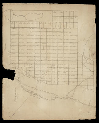
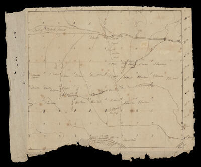
Osher Map Library Sheet Map Collection

4,458 results

Whales of the world 
Publisher:
Date/Date Range Produced: 1998
Language:
Dimensions: 52 x 74 cm
LC Call Number: QL737.C4 W49 1998x
OCLC: 52146901
Accession Number: OML-1998-93
Whales of the world 

Native American heritage : a visitors guide
Publisher:
Date/Date Range Produced: 1991
Language:
Dimensions: 49 x 71 cm
LC Call Number: G3701.E1 N3 1996
OCLC: 37526155
Accession Number: OML-1996-138
Native American heritage : a visitors guide

Land use around Jerusalem, March 1993
Publisher:
Date/Date Range Produced: 1993
Language:
Dimensions: 90 x 60 cm
LC Call Number: G7504.J4G4 1993 .U5 
OCLC: 31412673
Accession Number: OML-1993-121
Land use around Jerusalem, March 1993

Map of Europe showing the railways open and in progress to accompany Harper's Handbook
Publisher:
Language:
Region Depicted:
Map Type:
Dimensions: 53 x 63 cm on sheet 57 x 64 cm
LC Call Number: G5701.P3 1871 H3
OCLC: 1374072610
Accession Number: AUL-1871-38.2
Map of Europe showing the railways open and in progress to accompany Harper's Handbook

Route of the Mormon pioneers from Nauvoo to Great Salt Lake : Feb'y 1846-July 1847
Printmaker:
Publisher:
Date/Date Range Produced: 1899
Language:
Region Depicted:
Map Type:
Dimensions: 19 x 65 cm, on sheet 22 x 70 cm, folded to 18 x 11 cm
Printing Process:
Historical Context: The pictorial map chronicles the westward migration of Mormon pioneers from Nauvoo, Illinois to Great Salt Lake, Utah from 1846-1847. Because of tensions between Mormons and Nauvoo residents it was decided to go out west. Map depicts the Mormon Trail illustrating wagon trains, Indian tepees, western scenery.
LC Call Number: G4051.S1 1899.M5
OCLC: 865026422
Accession Number: OML-1899-97
Route of the Mormon pioneers from Nauvoo to Great Salt Lake : Feb'y 1846-July 1847

Library war service of the American Library Association : every dot on the map means a special war library for our fighting men : United War Work Campaign--week of November 11, 1918
Publisher:
Date/Date Range Produced: 1918
Language:
Region Depicted:
Dimensions: 53 x 65 cm
Historical Context: The Library War Service was established by the American Library Association to provide library services to soldiers between 1917 and 1920. The service built thirty-six libraries on military camps around the United States and distributed books and magazines to American servicemen. The map was created and published by the American Library Association on the week of November 11, 1918, Armistice Day.
LC Call Number: G3701.E67 1918.L53
OCLC: 1065744694
Accession Number: OML-1918-126
Subjects:
Library war service of the American Library Association : every dot on the map means a special war library for our fighting men : United War Work Campaign--week of November 11, 1918

Russian sea power
Creator:
Publisher:
Date/Date Range Produced: 1968
Language:
Dimensions: 40 x 36 cm
LC Call Number: G3201.R5 1968 .C49
OCLC: 872395975
Accession Number: OML-1968-228
See Also:
Russian sea power

U.S.S.R. - major ethnic groups
Publisher:
Date/Date Range Produced: 1969
Language:
Region Depicted:
Dimensions: 42 x 66 cm
LC Call Number: G7001.E1 1969 .U5
OCLC: 44995527
Accession Number: OML-1969-199
See Also:
Subjects:
U.S.S.R. - major ethnic groups

World News of the Week - victory Europe edition
Publisher:
Date/Date Range Produced: 1945
Language:
Region Depicted:
Dimensions: 89 x 119 cm., folded to 30 x 23 cm
Accession Number: OML-1945-186
See Also:
Subjects:
World News of the Week - victory Europe edition

World danger areas
Creator:
Publisher:
Date/Date Range Produced: Aug 8th, 1950
Language:
Region Depicted:
Material Type:
Accession Number: OML-1950-240
See Also:
World danger areas