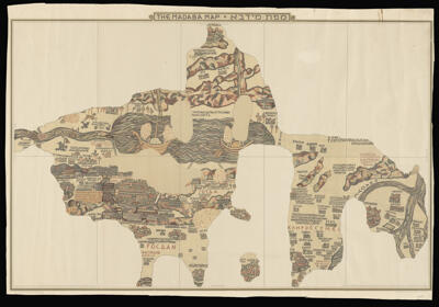
Osher Map Library Sheet Map Collection

4,673 results

Our Pin-up Girl
Publisher:
Language:
Region Depicted:
Map Type:
Dimensions: 14 x 18 cm on sheet 29 x 20 cm
LC Call Number: G3861.P3 1946 S6
OCLC: 1400073145
Accession Number: OML-1946-151
Our Pin-up Girl

The Confederate States of America
Creator:
Date/Date Range Produced: 1997
Language:
Region Depicted:
Map Type:
Dimensions: 55 x 43 cm
Historical Context: Depicts the Confederate perspective on the Civil War fought from 1861-1865 between the Confederate States of America and the Union. 
LC Call Number: G1281.S9 1863 K57
OCLC: 146371865
Accession Number: OML-1997-99
The Confederate States of America

Map of the United States, the British provinces, Mexico and C.: showing the routes of the U.S. mail, and a plan of the gold region
Printmaker:
Publisher:
Date/Date Range Produced: 1849
Language:
Region Depicted:
Map Type:
Dimensions: 1 map: 51 cm x 66 cm onsheet; 39 cm x 56 cm neatline
LC Call Number: G3700 1849.C6
OCLC: 1403565160
Accession Number: OML-1849-43
Map of the United States, the British provinces, Mexico and C.: showing the routes of the U.S. mail, and a plan of the gold region

The Madaba Map
Publisher:
Date/Date Range Produced: 1954
Language:
Region Depicted:
Map Type:
Dimensions: 52 cm x 75 cm on sheet; 47 cm x 74 cm neat line
Printing Process:
Historical Context: The Madaba map is the world's oldest mosaic floor map and one of the earliest depictions of the Holy Land. It was constructed during the 6th century C.E. to adorn the floor of a Byzantine church in Madaba, Jordan then part of the Roman Empire. This depiction of the map was first illustrated by Paul Palmer who was an architect in Jerusalem. Together with Hermann Guthe they published Die Mosaikkarte von Madeba published in Leipzig by Baedeker in 1906. This image was reproduced by the Survey of Israel in 1954. Religious sites are oversized given their importance and emphasizing the Church of the Holy Sepulchre, the Jordan Valley and the Dead Sea.
LC Call Number: G2230 .A9 1954
OCLC: 156939808
Accession Number: OML-1954-161
The Madaba Map

Wesley Township no. 25 and 26
Printmaker:
Date/Date Range Produced: 1815
Language:
Region Depicted:
Map Type:
Dimensions: 34 x 24 cm on sheet 42 x 27 cm
LC Call Number: G3734.W44 1815 D6
OCLC: 1401637219
Accession Number: OML-1815-20
Wesley Township no. 25 and 26

Township no. 6
Surveyor:
Date/Date Range Produced: 1833 - 1835
Language:
Region Depicted:
Map Type:
Dimensions: 42 x 36 cm
Printing Technique:
LC Call Number: G3734.W36 1835 D6
OCLC: 1401831606
Accession Number: OML-1835-57
Township no. 6

Plan of Phineas Osgood Estate
Surveyor:
Date/Date Range Produced: 1834
Language:
Region Depicted:
Map Type:
Dimensions: 39 x 33 cm on sheet 33 x 34 cm
Printing Technique:
LC Call Number: G3734.B57 1834 D6
OCLC: 1401935504
Accession Number: OML-1834-45
Plan of Phineas Osgood Estate

R.G.W. Dodge's Mill
Date/Date Range Produced: 1828 - 1839
Language:
Region Depicted:
Map Type:
Dimensions: 48 x 66 cm
LC Call Number: G3734.B57 1839
OCLC: 1402181310
Accession Number: OML-1839-56
R.G.W. Dodge's Mill

Indian Tribes and Trapper Trails
Creator:
Date/Date Range Produced: 1949
Language:
Region Depicted:
Map Type:
Dimensions: 27 cm x 44 cm, folded to 25 x 20 cm, in folder 27 x 22 cm
Material Type:
LC Call Number: G4501 1949.G3
OCLC: 8459955
Accession Number: OML-1949-184
Indian Tribes and Trapper Trails

Election Map and 1960 Presidential Fact Sheet
Publisher:
Date/Date Range Produced: 1960
Language:
Region Depicted:
Map Type:
Dimensions: 47 cm x 65 cm, folded to 24 cm x 17 cm
Material Type:
Historical Context: The 1960 election featuring John F. Kennedy, Democrat and Richard M. Nixon, Republican. Illustrations include a map showing key to elections and election scoreboard. Included are portraits of the presidents from George Washington to Dwight D. Eisenhower. Also included are images of Kennedy and Nixon. Kennedy won the election.
LC Call Number: JK528.E44 1960
OCLC: 660052801
Accession Number: OML-1960-276
Election Map and 1960 Presidential Fact Sheet