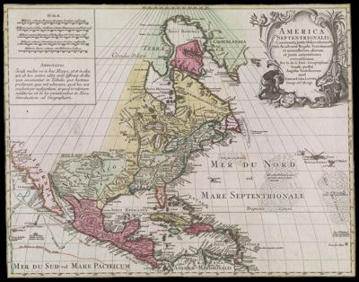
Chart of Falmouth Harbour
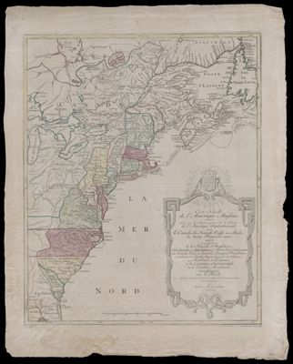
Creator: Des Barres, Joseph F. W. (Joseph Frederick Wallet), 1729-1824Publisher: Des Barres, Joseph F. W. (Joseph Frederick Wallet), 1729-1824Surveyor: Holland, Samuel, 1728-1801Language: EnglishRegion Depicted: Casco Bay, MaineMaine coastPortland Harbor, MaineSouth Portland, MaineMap Type: GeographicalNautical chartsDimensions: Chart: 74.5 x 53.5 cm on sheet: 79.5 x 59 cm
Printing Process: EngravingMaterial Type: PaperHistorical Context: Chart of Casco Bay, originally published in London at the beginning of the Revolution, provides the first detailed view of the Portland peninsula, then called Falmouth Neck.
LC Call Number: G3732.P6 D4 1776
OCLC: 229892607
Accession Number: SM-1776-16
See Also: A Chart of Delawar Bay.Chart of Coast from Pemaquid Point to Owl's Head Bay [sheet 1]Chart of Coast from Pemaquid Point to Owl's Head Bay [sheet 2]Chart of Coast from Pemaquid Point to Owls Head BayChart of Falmouth HarbourChart of Falmouth HarbourChart of Grand Manan IslandChart of Passamaquody BayChart of Penobscot Bay (Upper Part)Chart of the Coast from Burntcoal Island to Skulock PointChart of the Coast from Cape Elizabeth to Musketo IslandChart of the Coast from Cape Elizabeth to Musketo Island Chart of the Coast from Musketo Island to Skuttock PointChart of the Coast Goldsborough to Moose Harbor [Sheet 2 of 3]Chart of the Coast Goldsborough to Moose Harbor [Sheet 3 of 3]Chart of the Coast Goldsborough to Moose Harbor. [Sheet 1 of 3]Chart of the Coast Goldsborough to Moose HarbourChart of the Coast of GeorgiaChart of the Entrance into Penobscot BayChart of the Entrance into Penobscot BayChart of the Harbours and Rivers between Portland Point and Stage IslandChart of the Harbours and Rivers between Portland Point and Stage IslandCharts of the Coast and Harbors of New England [...] [Title page]Coast from Newbury to Cape ElizabethFalmouth Harbor Portland Sound [facsimile]Notes Biographical and Bibliographical on The Atlantic NeptuneNotes Biographical and Bibliographical on The Atlantic Neptune [Front cover]The Coast of New England.United States East Coast Maine Frenchman's Bay and eastern part of Mt. Desert Island[Boston Harbor Chart Des Barres] [facsimile][Coast of Maine - from Spurwink River to Moose Point] [or, from Musketo Island to Cape Elizabeth, including Kennebec River] [facsimile][Coast of Maine - Two Views of Wolves Islands at Entrance of Passamaquoddy Bay][Coast of Maine]Donor: SmithSubjects: American Revolution, 1775-1783Colonial AmericaMaine--Maps