Smith Sheet Map Collection
429 results
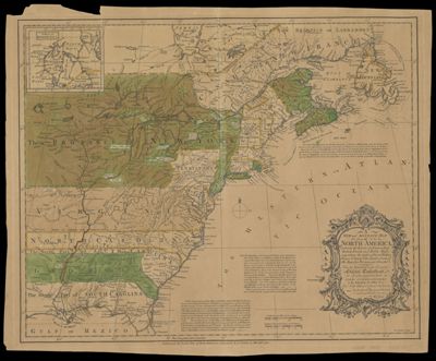
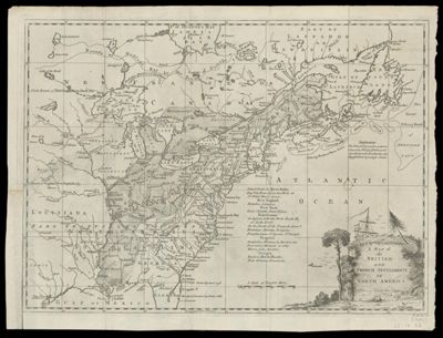
A Map of the British and French Settlements in North America : [Part the second] containing Part of New York, Pensilvania, New Jersey, Mary Land, Virginia, North & South Carolina, Georgia, Louisiana, and all the Countries Westward in the same Parallels so far as Discovered, shewing the Course of the Rivers Ohio, Missisipi &c., exhibiting the just Boundaries & the French Encroachments Laid down from Authentic Surveys.
Date/Date Range Produced: 1759
Language: EnglishRegion Depicted: Eastern United StatesLouisianaMarylandNorth AmericaNorth CarolinaOhioPennsylvaniaSouth CarolinaVirginiaDimensions: H 22.5 x W 54.9 cm
Printing Process: EngravingMaterial Type: PaperLC Call Number: G3230 .B6 1759
OCLC: 138099215
Accession Number: SM-1759-5
Donor: Smith
![]()
![A Map of the British and French Settlements in North America : [Part the second] containing Part of New York, Pensilvania, New Jersey, Mary Land, Virginia, North & South Carolina, Georgia, Louisiana, and all the Countries Westward in the same Parallels so far as Discovered, shewing the Course of the Rivers Ohio, Missisipi &c., exhibiting the just Boundaries & the French Encroachments Laid down from Authentic Surveys.](https://cdn1.historyit.com/iiif/2/5f34291499c4a6.60628694/66ba0908a04a13.44789385.jpg/full/!400,400/0/default.jpg?no_errors=1)