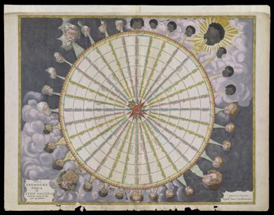
Tabula Anemographica Seu Pyxis Navtica Ventorum nomina sex linguis repraesentans
Creator: Jansson, Jan, 1588-1664Atlas Reference: Atlas novus, ca. 1680Date/Date Range Produced: 1680
Language: LatinMap Type: Thematic mapsDimensions: H 47.1 x W 60.5 cm
Printing Process: EngravingMaterial Type: PaperHistorical Context: Over the centuries, an increased diversity of names for the winds and ambiguity about the direction they came from, produced a multitude of different wind systems. To create order out of the tangled confusion of names and directions, cartographers produced wind roses such as this by Jan Jansson in 1650. Thirty-two points (directions) are shown and labeled with various directional names for the winds. But to sailors plying the waters of the open oceans, a wind blowing from Thrace (Thracias) lost all relevance in defining direction. Eventually, the wind rose, overburdened by a multiplicity of names and obtuse symbolism, gave way to the directional system of north, east, south, and west, with their intermediate compounds, as used today. Note the fledgling emergence at the perimeter of the circle of a more abstract directional system--degrees of arc of a circle. Even here, the cartographer is unable to resist introducing variations. In the areas surrounding the ring, each wind is personified by a figure bearing the racial characteristics associated with the region or direction represented. The upper left quadrant, representing north, depicts bearded Germans or Scandinavians. The upper right, representing east, shows beardless dark skinned faces. The beardless and pale skinned figures in the lower left and right, representing west and south, are less distinguishable but are possibly intended to represent indigenous Americans and Greeks.
LC Call Number: GA6 .J3 1680
OCLC: 229892624
Accession Number: SM-1680-15
Donor: Smith