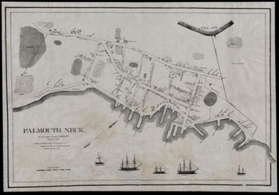
Falmouth Neck, As it was when destroyed by Mowett, Oct. 18, 1775.
Creator: Willis, William, 1794-1870Publisher: Willis, William, 1794-1870Language: EnglishRegion Depicted: Falmouth Neck, MaineMainePortland Harbor, MainePortland, MaineMap Type: City mapsGeographicalHistorical mapsDimensions: 44.5 x 64.5 cm
Printing Process: LithographMaterial Type: PaperHistorical Context: Lithographic reproduction of engravings of the British vessels Spitfire Bomb, Cat, Store and Canceau commanded by Henry Mowat who ordered the bombardment of Falmouth Neck. The Burning of Falmouth (October 18, 1775) was an attack by a fleet of Royal Navy vessels on the town of Falmouth, Massachusetts (site of the modern city of Portland, Maine). The attack began with a naval bombardment, followed by a landing party meant to complete the town's destruction. The attack was the only major event in what was supposed to be a campaign of retaliation against ports that supported Patriot activities in the early stages of the American Revolutionary War.
LC Call Number: G3731.R3 W5 1831
OCLC: 58436634
Accession Number: OS-1831-17
Donor: OsherSubjects: American Revolution, 1775-1783Colonial AmericaFalmouth (Me.) History Burning by the British, 1775Maine--MapsMowat, Henry, 1734-1798Sailing shipsUnited States--History--Revolution, 1775-1783Warships