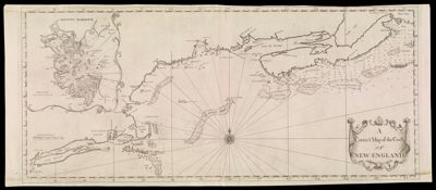
A Correct Map of the Coast of New England. 1731Creator:Southack, Cyprian, 1662-1745 Date/Date Range Produced: 1731 Language:English Map Type:Nautical charts Dimensions: 45 cm. x 105 cm. on sheet 48 cm. x 115 cm. Printing Process:Engraving Material Type:Paper Historical Context: Cyprian Southack was and English sea captain and privateer who came to Boston in 1685 for privateering and maritime interests along the New England coast. He drew maps for the New England Coasting Pilot (1729-1734). LC Call Number: G3720 1731.S6 OCLC: 986799721 Accession Number: OS-1731-2 Donor:Osher