About
Staff
Collections
Imaging Services
Donations and Gifts
Student Employment
Research Fellowships
History
Contact Us
Visit
Plan Your Visit
Directions and Parking
Research Visit
K-12 Field Trips
Group Tours
Teach
Book a K-12 Visit or Kit
Field Trips
Classroom Activity Kits
Downloadables
Professional Development
Mapmaking Contest
Summer Camp
Lewiston-Auburn Education & Community Map Lab
News & Events
Blog
Browse Maps
Exhibits and Reference
Gallery Exhibits
Map Commentaries
Digital Exhibits
Search Library Catalog
Digital Commons
Ask a Librarian
ADVANCED SEARCH
HOME
|
Collection
About
Staff
Collections
Imaging Services
Donations and Gifts
Student Employment
Research Fellowships
History
Contact Us
Visit
Plan Your Visit
Directions and Parking
Research Visit
K-12 Field Trips
Group Tours
Teach
Book a K-12 Visit or Kit
Field Trips
Classroom Activity Kits
Downloadables
Professional Development
Mapmaking Contest
Summer Camp
Lewiston-Auburn Education & Community Map Lab
News & Events
Blog
Browse Maps
Exhibits and Reference
Gallery Exhibits
Map Commentaries
Digital Exhibits
Search Library Catalog
Digital Commons
Ask a Librarian
ADVANCED SEARCH
Osher Sheet Map Collection
2,262 results
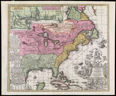
Accurata delineatio celeberrimae Regionis Ludovicianae vel Gallice Louisiane et Canadae et Floridae adpellatione in Septemtrionali America descriptae quoe hodie nomine fluminis Mississippi vel St. Louis per colonias et navigationes Gallorum ob immensas opes et adfluentiam magis magisque inclarescit ex fide digniss. Itiner ariis consignata et in lucem edita cura et manu Matthaei Seutteri, S.C.M.G. Augustan.
Creator:
Rogg, Gottfried, 1669-1742
Seutter, Matthaeus, 1678-1756
Date/Date Range Produced:
1734
Language:
French
Latin
Region Depicted:
Bahamas
Cuba
Mexico
Newfoundland and Labrador
Nova Scotia
Ontario
United States
Map Type:
Geographical
Political maps
Dimensions:
H 53 x W 63.8 cm
Printing Process:
Engraving
Material Type:
Paper
Accession Number:
OS-1734-6
Donor:
Osher
Subjects:
Anthropomorphism
Bahamas
Capitalists and financiers
Cherubs (Art)
Colonial America
Cuba
Indians of North America
Maps--Early works to 1800
Mexico
Native Americans
Newfoundland and Labrador
Nova Scotia (Canada)
Ontario
Quebec (Province)
Suicide
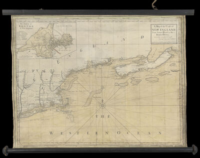
A Map of the Coast of New England, from Staten Island to the Island of Breton, as it was actualy Survey'd by Capt. Cyprian Southack. Sold by Iohn Senex at the Globe overagainst St. Dunstan's Church in Fleetstreet: who also makes & sells Globes & Maps with new improvements
Creator:
Senex, John 1678-1740
Southack, Cyprian, 1662-1745
Publisher:
Mount, William, -1769
Purveyor:
Senex, John 1678-1740
Date/Date Range Produced:
1735
Language:
English
Region Depicted:
Connecticut
Long Island, New York
Maine
Massachusetts
New England
New Hampshire
Nova Scotia
Rhode Island
Map Type:
Nautical charts
Dimensions:
H 67.5 x W 92 cm
Printing Process:
Engraving
Material Type:
Paper
OCLC:
86085001
Accession Number:
OS-1735-1
Donor:
Osher
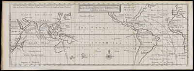
A View of the General Trade-Winds, Monsoons, or Shifting-Winds, & Coasting-Winds, through ye World, Variations, &c, by H. Moll Geographer
Creator:
Moll, Herman, 1654 -1732
Date/Date Range Produced:
1736
Language:
English
Dimensions:
H 19.8 x W 54.5 cm
Printing Process:
Engraving
Material Type:
Paper
OCLC:
39720291
Accession Number:
OS-1736-1
Donor:
Osher
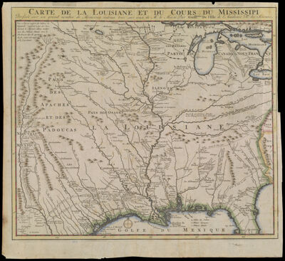
Carte de la Louisiane et du Cours du Mississipi Dressee sur un grand nombre de Memoires entrau tres sur ceux de Mr. le Maire par Guillaume de l'Isle de l'Academie Rle. des Sciences.
Creator:
Bernard, Jean-Frédéric, 1683?-1744
L'Isle, Guillaume de, 1675-1726
Date/Date Range Produced:
1737
Language:
French
Region Depicted:
United States
Map Type:
Geographical
Dimensions:
H 39 x W 42.8 cm
Printing Process:
Engraving
Material Type:
Paper
LC Call Number:
G3701.S2 1737.L51
OCLC:
316460198
Accession Number:
OS-1737-1
Donor:
Osher
Subjects:
Indians of North America
L'Isle, Guillaume de, 1675-1726
Maps--Early works to 1800
Native Americans
United States
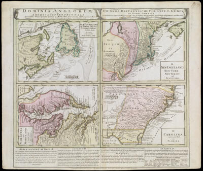
Domina Anglorum in America Septentrionali
Creator:
Moll, Herman, 1654 -1732
Date/Date Range Produced:
1737
Language:
Dutch
Latin
Dimensions:
4 maps: each 20 cm. by 28 cm. on sheet 53 cm. x 63 cm.
Printing Process:
Engraving
Material Type:
Paper
LC Call Number:
G3300 1737.H65x
OCLC:
83998379
Accession Number:
OS-1737-5
Donor:
Osher
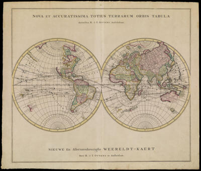
Nova et Accuratissima Totius Terrarum Orbis Tabula Auctoribus R. & I. Ottens Amstelodami.
Creator:
R. & J. Ottens
Publisher:
R. & J. Ottens
Date/Date Range Produced:
1739
Language:
Dutch
Latin
Region Depicted:
World
Map Type:
Geographical
Dimensions:
2 hemispheres: each 30 cm. in diam. on sheet 52 x 59 cm.
Printing Process:
Engraving
Material Type:
Paper
OCLC:
854762954
Accession Number:
OS-1739-3
Donor:
Osher
Subjects:
Maps--Early works to 1800
R. & J. Ottens
World maps
A Chart Shewing the Several Places of Action between the English and Spanish Fleets with the Places where several of the Spanish Ships were destroyed in their return to Spain, North about the British Isles.
Creator:
Gravelot, Hubert François, 1699-1773
Pine, John, 1690-1756
Date/Date Range Produced:
1739
Language:
English
Dimensions:
H 47.5 x W 67.7 cm
Printing Process:
Engraving
Material Type:
Paper
OCLC:
854765426
Accession Number:
OS-1739-4
Donor:
Osher
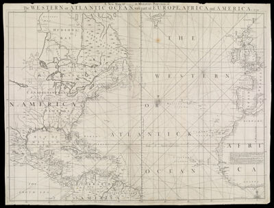
A New Map, or (illegible) in Mercators Projection, of the Western or Atlantic Ocean, with part of Europe, Africa and America 1739.
Creator:
Senex, John 1678-1740
Date/Date Range Produced:
1739
Language:
English
Dimensions:
H 61.5 x W 80.5 cm
Printing Process:
Engraving
Material Type:
Paper
Accession Number:
OS-1739-5
Donor:
Osher
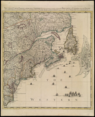
Nouvelle Carte Particuliere de L'Amerique ou sont exactement marquees la Nouvelle Bretagne, le Canada ou Nouvelle France, la Nouvelle Ecosse, la Nouvelle Angleterre, la Nouvelle York, la Pensilvanie, Mary-Land, la Caroline Septentrionale l'Ile de Terre Nueve, le Grand Banc &c.
Creator:
Popple, Henry, -1743
Publisher:
Cóvens et Mortier
Date/Date Range Produced:
1741
Language:
English
French
Region Depicted:
Atlantic States
Canada
Connecticut
Delaware
Maine
Maryland
Massachusetts
New England
New Hampshire
New Jersey
New York (State)
Newfoundland and Labrador
North Carolina
Nova Scotia
Pennsylvania
Rhode Island
Vermont
Virginia
Map Type:
Geographical
Political maps
Dimensions:
H 53.7 x W 66.3 cm
Printing Process:
Engraving
Material Type:
Paper
Accession Number:
OS-1741-1
Donor:
Osher
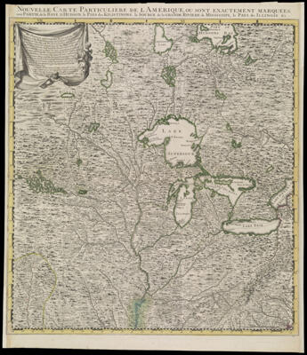
Nouvelle Carte Particuliere de L'Amerique, ou Sont Exactement Marquees, une Partie de la Baye d'Hudson, le Pays de Kilistinons, la Source de la Grande Riviere de Mississipi, le Pays des Illinois &c.
Creator:
Popple, Henry, -1743
Publisher:
Cóvens et Mortier
Date/Date Range Produced:
1741
Language:
English
French
Region Depicted:
Arkansas
Canada
Illinois
Indiana
Iowa
Kansas
Kentucky
Manitoba, Canada
Michigan
Midwestern United States
Minnesota
Missouri
Nebraska
North Carolina
Ohio
Ontario
Texas
United States
Virginia
West Virginia
Wisconsin
Map Type:
Geographical
Dimensions:
H 54.6 x W 64 cm
Printing Process:
Engraving
Material Type:
Paper
OCLC:
880677418
Accession Number:
OS-1741-2
Donor:
Osher
33
34
35
36
37
38
39
40
41
42
×
Basic Search
Advanced Search
Site Search
Keyword
Start Year
End year
Show only results with images
Exact match?
SEARCH
KEYWORD
TITLE
REGION DEPICTED
CREATOR/Printmaker
START YEAR
END YEAR
SUBJECT
BARCODE
Item Type
<select>
Artifact
Atlas
AV
Book
Document
Ephemera
Globe
Image
Serial
Sheet Map
Type
<select>
Account books
Advertisements
Advertising cards
Albums (books)
Ambrotypes
Astrolabe
Astronomical Models
Audio Discs
Audiocassettes
Audiotapes
Automobile License Plates
Baseball Caps
Bells
Board games (game sets)
Bookplates
Broadsides
Brochures
Bumper stickers
Business cards
Buttons
Calendars
Cameras
Campaign button
Card photographs
Cassette Tape
Celluloid Buttons
Certificates
Chinaware
Circular letters
Clippings
Clothing
Commonplace books
Compact Discs
Computer Programs
Containers
Cookie Cutters
Copybooks (instructional materials)
Correspondence
Cyanotypes
Cylinder Recordings
DVDs
Decals
Deeds
Diaries
Digital
Drafting Tools
Drawings
Embroidery
Envelopes
Family papers
Fans (ephemera)
Film Reels
Film negatives
Filmstrips
Game pieces
Gameboards
Games
Glass negatives
Greeting cards
Handkerchiefs
Hats
Invitations
Jewelry
Journals (accounts)
Keepsakes
Key chains
Landscape photographs
Lantern slides
Letterheads
Luggage tags
Manufacturers' catalogs
Manuscripts
Marbles (game pieces)
Membership cards
Membership certificates
Memorabilia
Menus
Microfilms
Model
Motion Picture Cameras
Needlepoint
Notebooks
Other/Unknown
Paintings
Pamphlets
Passports
Pencil sharpeners
Periodical illustrations
Phonograph Records
Photograph albums
Photographic postcards
Photographs
Photography Equipment and Supplies
Pictorial envelopes
Pin
Postage stamps
Postcards
Posters
Presentation albums
Price lists
Printing Equipment
Prints
Programs
Puzzles
Receipts (financial record)
Receipts (financial records)
Rewards of merit
Rolodex
Schedules
Scrapbooks
Sculpted Object
Sextant
Ships' logs
Signs
Sketches
Slides
Sound Recordings
Souvenirs
Stationary
Stereographs
Stickers
Surveying Tools
T-shirts
Tape Reels
Textiles
Tickets
Timetables
Tintypes
Title pages
Toys
Trade cards
Transparencies
Transportation tickets
Travel sketches
VHS
Videocassettes
Videodiscs
Viewbooks
Vinyl Records
Watercolors (paintings)
Wills
Writing Instruments
Map Type
<select>
Aerial photographs
Aeronautical charts
Astronomical charts
Bird's-eye views
Boundary maps
Braille maps
Cadastral maps
Celestial charts
Census maps
Chorographic maps
City maps
Climactic maps
Diagram
Digital maps
Engineering maps
Fire insurance maps
Geographical
Geological maps
Historical maps
Land use maps
Manuscript maps
Military maps
Nautical charts
Navigation charts
Panoramas
Pictorial maps
Political maps
Population maps
Portolan charts
Property maps
Railroad maps
Raised-relief maps
Relief maps
Road maps
Statistical maps
Tactical maps
Thematic maps
Topographical maps
Tourist maps
Transportation maps
Views
Wall maps
Zoning maps
Donor
<select>
470 Railroad Club
Acadian Archives
Achs
American Textile History Museum
Anderson
Antonacos
Arader
Arsenault
Auletta
Ball State University
Bangor Public Library
Baresei
Barthelman
Baskes
Bates
Bates College Library
Bean
Bellemere
Berkley
Bischof
Bloom
Bonebakker
Bouzrara
Bradt
Bresler
Bresloff
Brown, B.
Brown, H.
Buehler
Burns
CG
Callanan
Carhart
Carpenter
Cartmill
Chase
Chase Vinton
Chassé
Chazaud
Christian
Christoforo
Christopher
Clark
Colorado School of Mines
Corse
Cosgrove
Cotsen
Crawford
Croft
D'Anci
Dahl
Dale
Dalton
Dancause
Davis, G.
Davis, M.
Deering
Dodge
Donovan
Draper
Duclos
Dunn
EIS
Eastman
Eclectibles
Edney
Edward E. Chase Family
Eliot
Ellenberger
Elze
Engass
Epstein
Estate of Chester Chase
Ettenger
Farmington
Flaherty
Fleet Bank
Flowerdew
Flynn
Foster
Fowler
Freidman
French
Galvin
Gardner
Garland
Gibb
Gorham Library
Gould Cheseboro
Greater Portland Council of Governments
Green
Griffin
Gurtman
Hall
Hamill
Hamilton
Hamilton-Thayer
Hanly
Hardenbergh
Haupt
Hawes
Hermann
Hickey
Hirst
Hodges
Holland
Holmberg
Holtwijk
Hopewell
Hornsby
Horowitz
Horwitz
Houghton
Hovey
Howard
Howell
Hunt
Hunter
J. Moore
Jackson
Joel Osher
Jordon
Kaufman
Kaufman, R.
Kellogg
Kelly
Kelsey
Kendall
Knowlton
Kurtz
LaMonica
Lahti
Leboutillier
Levin
Libby
Library of Congress
Lindl
Lisberger
Lumbert
MacGregor
Maine Historical Society
Maine State Library
Major
Mann
Marci
Marsh
Matthews
Maxwell/Wheeler
McCrum
McHugh
McMahon
McMorrow
Meeker
Meinig
Meyer
Michie
Michigan State University
Mitchell
Monkhouse
Moore
Morelli
Morin
Morris
Morse
Mosher
Mountford
Naden
Nancy Lane
Nashville Public Library
Neikirk
Nelson
Neuschaffer
Newick
Nickerson
Nunley
Nutty
Nyberg
O'Brien
Osher
Osher Lifelong Learning Institute
Owen
Padula
Paine
Paradis
Patenaude
Peabody Museum of Archeology
Pendexter
Perry
Peterson
Picton
Pomeroy
Pope
Porobic
Pratt
Prieto
Pringle
Rea
Rees
Riback
Rice
Robinson/J. Walkling
Rockport Public Library
Ronan
Roos
Ruderman
Russell
Sandford
Sataloff
Sawyer
Seavey
Sewell Corp.
Shain
Sharp
Shettleworth
Simpson
Skiff
Skye
Smiley
Smith
Solomon
Sorin
South Portland Housing Authority
Spencer
Stead
Stephenson
Story
Thompson
Thompson Public Library
Tilton
Tomazin
Topol
Torodash
Town of Whitefield, Maine
Tremper
Tupper
Turner
UMaine Farmington Mantor Library
USM Franco-American Collection
USM Geo/Anthro Department
University of Maine Fogler Library
University of Maine Law Library
University of North Carolina
University of Southern Maine President's Office
University of Vermont, Special Collections
Usenik
Walkling
Waters
Webb
Webber
Weld Historical Society
Wendell-Thorpe
Whitman
Whitten
Willette
Williams
Williamson
Willson
Wind
Witham
Witty
Wood
Woodbury
Woods Hole
Wurtz
Yensen
Yorke
Language
Dedicatee
Editor/Translator
Publisher
Purveyor
Surveyor
Printing Process/Technique
<select>
3-D
Aquatint
Blueprint
Cerography
Digital
Electrotype
Engraving
Etching
Line Engraving
Lithograph
Mezzotint
Not Specified
Offset Printing
Relief
Relief Cut (facsimile)
Steel engraving
Stereotyping
Wood engraving
Woodblock
Aluminum
Copper
Copper Letterpress
Letterpress
Linoleum
Manuscript
Not Specified
Planar Surface
Steel
Stone
Wax
Wood
Wood Letterpress
Wood Letterpress Manuscript
Zinc
Material Type
<select>
Ceramic
Cloth
Copper
Glass
Leather
Linen
Metal
Mylar (modern drafting)
Newsprint
Paper
Papier mache
Plaster
Plastic
Rubber
Silk (textile)
Vellum (parchment)
Wood
Show only results with images
Exact match?
More +
less -
SEARCH
Keyword
SEARCH