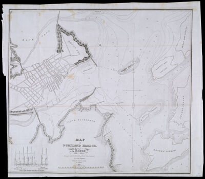
Map of Portland Harbor. Maine Surveyed under the direction of Lt. Col. John Anderson, U.S. Top. Engineer. Drawn by Lieut. B. Poole, 3d Artillery 1833
Creator: Poole, Benjamin, -1839Surveyor: Anderson, JohnDate/Date Range Produced: 1833
Language: EnglishRegion Depicted: Cape Elizabeth, MainePortland Harbor, MaineMap Type: Nautical chartsDimensions: H 48.4 x W 55.9 cm
Printing Process: EngravingMaterial Type: PaperHistorical Context: By 1833 sufficient soundings taken in Portland harbor enabled the cartographer of this large-scale chart to create a topographic map of the sea bottom. Isobars--lines connecting equal depth-- give the navigator a comprehensive description of what he will encounter on all routes and points of sailing. As a further aid, the position of buoys are shown, to warn the navigator of danger. Depths are indicated in fathoms at low water. Strong winds, however, can augment or diminish these soundings. A graphic depiction of the effect of wind on the tide is shown in the lower left corner of the chart.
LC Call Number: TC203 .P55 .P8 1833
OCLC: 55520526
Accession Number: OS-1833-5
Donor: OsherSubjects: CoastsIslandsMaine--MapsNautical chartsPortland (Me.)Portland Harbor, Maine