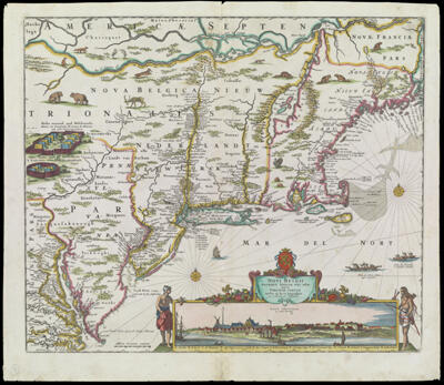
Novi Belgii Novaeque Angliae Nec Non Partis Virginiae Tabula Multis in locis emendata per Nicolaum Visscher
Creator: Visscher, Nicolaes, 1618-1679Date/Date Range Produced: 1683
Language: DutchLatinRegion Depicted: Eastern CanadaMiddle Atlantic StatesNew EnglandMap Type: GeographicalDimensions: 47 X 56 cm. on sheet 53 X 61 cm.
Printing Process: EngravingMaterial Type: PaperHistorical Context: This map is a prime example of seventeenth-century Dutch cartography at its best it combines accurate and detailed geography with elegant design, engraving, embellishment, and color. The geographic view from Chesapeake Bay to Penobscot Bay is the most advanced of its time, showing virtually all known towns and settlements, the locations of each Indian tribe encountered by the settlers, and the first relatively accurate delineation of the island of Manhattan. This map served as the model for maps of the region for nearly a century, and was used in 1685 for settlement of the boundary dispute between William Penn and Lord Baltimore. Tastefully applied outline color delineates boundaries of European colonies. Decorative vignettes positioned in otherwise empty spaces portray Indian stockades, indigenous animals and birds, two compass roses, a European sailing ship, and a native canoe and dugout The most remarkable decorative element is the panoramic inset view of "Nieuw Amsterdam" as it appeared in about 1652; this is the third known engraved view of New York, with its detailed depiction of topography, dwellings, the fort, a church, a windmill, a crane, and even a gallows!
OCLC: 882102587
Accession Number: OS-1683-1
Donor: Osher