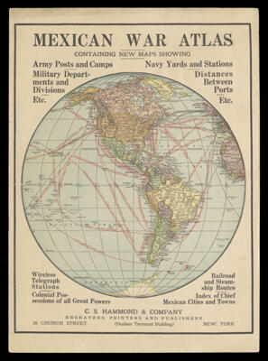
Osher Map Library Atlas Collection

785 results

Island Falls, Aroostook County, Maine
Publisher:
Date Produced: 1912
See Also:
OCLC: 231406862
Accession Number: OS-1912-130
Donor:
Island Falls, Aroostook County, Maine

Machias, Washington County, Maine : including Machias Port and East Machias
Publisher:
Date Produced: 1925
Physical Description: 8 maps : col. ; on sheets 64 x 54 cm
See Also:
OCLC: 232547274
Accession Number: OS-1925-186
Donor:
Machias, Washington County, Maine : including Machias Port and East Machias

Maine city & town atlas
Publisher:
Date Produced: 1987
Physical Description: 1 atlas (118 p.) : col. maps ; 31 cm
LC Call Number: G1216.A1 M356 1987
OCLC: 17440242
Accession Number: OML-1987-119
Donor:
Donation Date: Oct 15th, 2018
Maine city & town atlas

The Penobscot Bay resource plan
Publisher:
Date Produced: 1972
Physical Description: 38 p. : ill., maps ; 42 cm
LC Call Number: HC107.M2 .P468
OCLC: 3285456
Accession Number: OML-1972-146
Donor:
Donation Date: Oct 12th, 2018
The Penobscot Bay resource plan

Atlas of World History : A Series of Thirty-two Coloured Plates containing Eighty-two Maps with an Index to Place Names
Publisher:
Date Produced: 1958
Physical Description: 32 pages, 8 page index, 25 cm
LC Call Number: G1030 .J65 1958
Accession Number: OML-1958-126
Donor:
Donation Date: Oct 12th, 2018
Atlas of World History : A Series of Thirty-two Coloured Plates containing Eighty-two Maps with an Index to Place Names

The Vermont atlas and gazetteer
Publisher:
Date Produced: 1978
Physical Description: 33, 62 pages : illustrations, maps ; 40 cm
LC Call Number: G1225 .D3 1978
OCLC: 4765204
Accession Number: OML-1978-119
Donor:
Donation Date: Jan 10th, 2015
The Vermont atlas and gazetteer

Smith's atlas
Author:
Publisher:
Date Produced: 1839
LC Call Number: G1019 .S578 1839 c.3
OCLC: 19132541
Accession Number: OML-1839-49
Smith's atlas

Complete Road Map Massachusetts Rhode Island
Publisher:
Date Produced: 1905
Physical Description: 1 map in 5 sections, with title sheet : color ; 73 x 67 cm on sheets 77 x 70 cm folded to 39 x 36 cm in case 40 x 37 cm
LC Call Number: G3720.P1 1905 .S27 copy 2
OCLC: 17795924
Accession Number: OML-1905-137
Complete Road Map Massachusetts Rhode Island

[portfolio of Shell road maps]
Publisher:
Date Produced: 1956
Physical Description: 75 road maps with identifying tabs.
Accession Number: OML-1956-155
[portfolio of Shell road maps]

[portfolio of Conoco road maps]
Publisher:
Date Produced: 1936
Dimensions: 47 x 41 cm
Accession Number: OML-1936-154
[portfolio of Conoco road maps]