

The American public relied almost exclusively on newsprint and newsreels for information of the war as it unfolded. Maps, which were commonly associated with military strategy and espionage in the early twentieth century, became popular items in daily newspapers throughout the United States well before the country had officially joined the war. Some magazines and newspapers even distributed large war zone maps intended for long-term use; the text of these maps often instructed the user to update his or her copy with annotations or included flag cutouts.
Map companies such as Rand McNally produced a large number of up-to-date maps of the major war fronts, especially the Western Front. Sold at a variety of stores and costing only a quarter or two, these maps were another way for civilians to remain informed of the events and locations pertaining to the war.
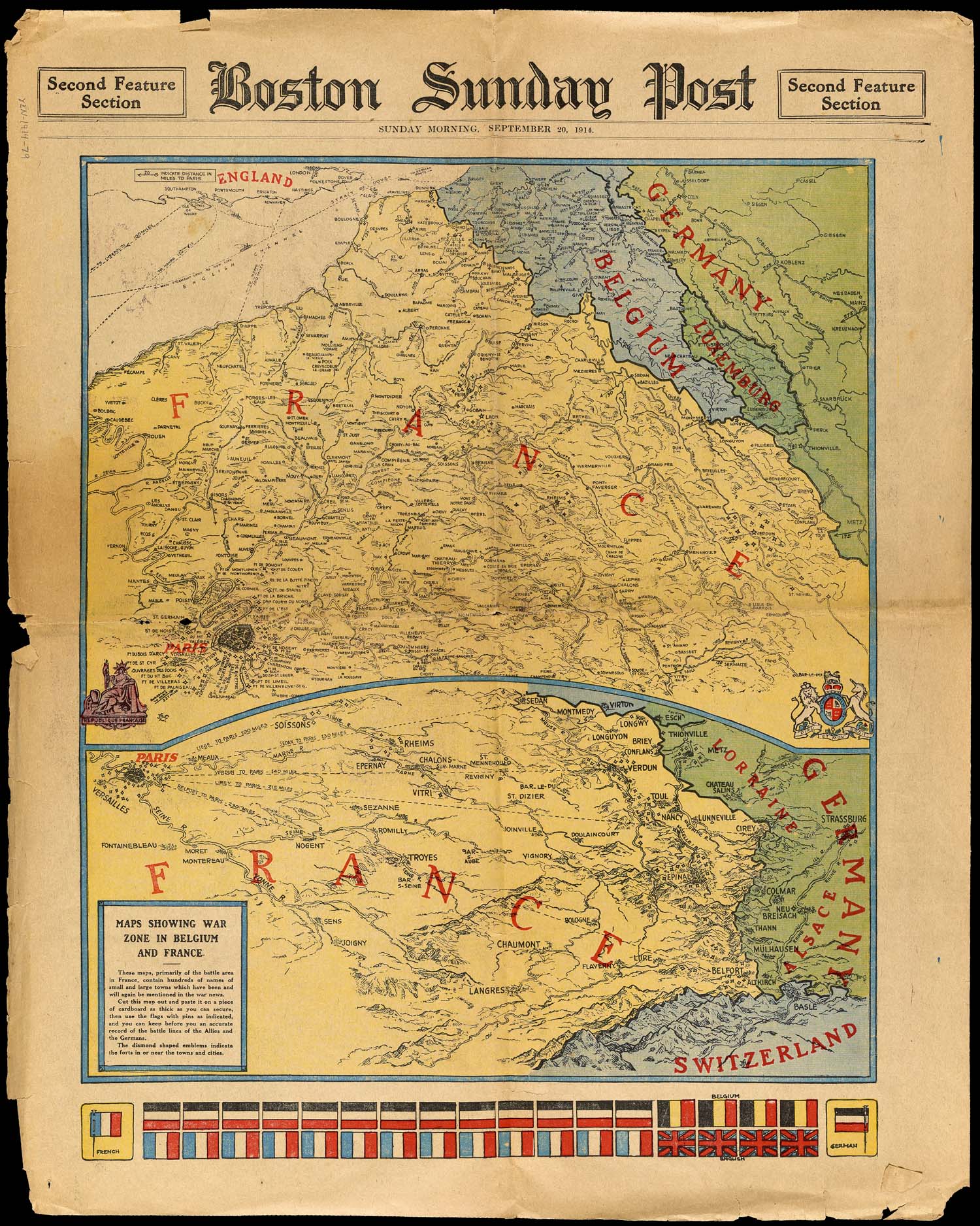
Printed on September 20, 1914, this front page map from the Boston Sunday Post shows the war zone in the early days of the Race to the Sea, when the Germans and the Allies each attempted to circumvent the northern limits of each other's defensive lines. However, neither side prevailed in the flanking maneuver. To defend against the threat of the enemy maneuvering around the northernmost point of their defenses, the armies continually extended their lines until the trench systems stretched all the way to the North Sea. Because the German army's movement was initially directed towards Paris, arrows pointing to the city appear throughout the map, each labeled with the number of miles between that point and Paris.
The map was printed with the knowledge that some readers would choose to save it, the instruction at the bottom reading, "Cut this map out and paste it on a piece of cardboard as thick as you can secure, then use the flags with pins as indicated and you can keep before you an accurate record of the battle lines of the Allies and the Germans." The cutout flags included thirteen German flags and thirteen French flags. The English and Belgians were only allotted four flags each, not surprising at this stage in the war. The British Expeditionary Force had seen its first combat less than a month earlier, and the Belgian military had already lost a significant percentage of its soldiers; by the end of the year, there would be only 60,000 men left in the entire Belgian army, a shocking number when compared to the 4.5 million men in the German military.
map/42761
15. Maps Showing War Zone in Belgium and France
Boston Sunday Post, 1914
Yensen Collection
URL: www.oshermaps.org/map/42761
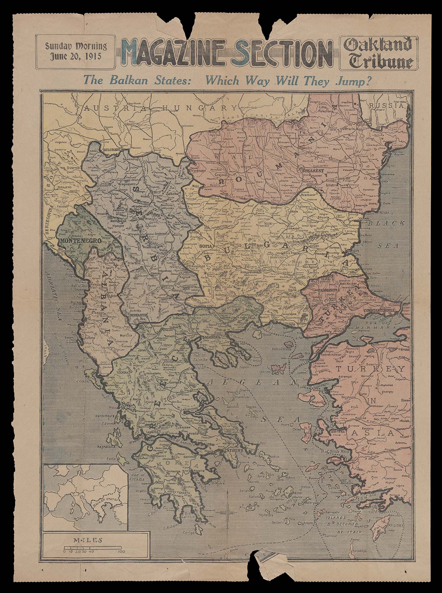
This newsmap was printed on the front page of the June 20, 1915 edition of the Oakland Tribune, and highlights the Balkan states of Serbia, Montenegro, Turkey, Bulgaria, Romania, Greece, and Albania. A key region in World War I, the Balkans saw the earliest events of the conflict, including the assassination of the Austrian Archduke Franz Ferdinand in Serbia in June, 1914. While the title of the map asks "Which Way Will They Jump," only four of the countries highlighted were presently uncommitted to a side: Greece, Romania, Bulgaria, and Albania. Serbia had been a central player early on, and was still an active party at the time this map was published. Later in the year, Serbia would fall to the Austrian-Hungarian forces, with their ally, Montenegro, falling soon after in January 1916. The Ottoman Empire had also been an early combatant in the war, joining the Central Powers in October 1914. By the time this map was printed, Albania, independent only since 1912, was in anarchy. Thus, the primary objects of speculation were Bulgaria, Romania, and Greece. Bulgaria would be the first to jump, joining the Central Powers in late 1915 after being promised the return of territory allocated to it in the Treaty of San Stefano. Romania "jumped" in 1916 to the Allied side, which Greece also joined the following year.
map/47695
16. The Balkan States: Which Way Will They Jump?
Oakland Tribune, 1915
OML Collection
URL: www.oshermaps.org/map/47695
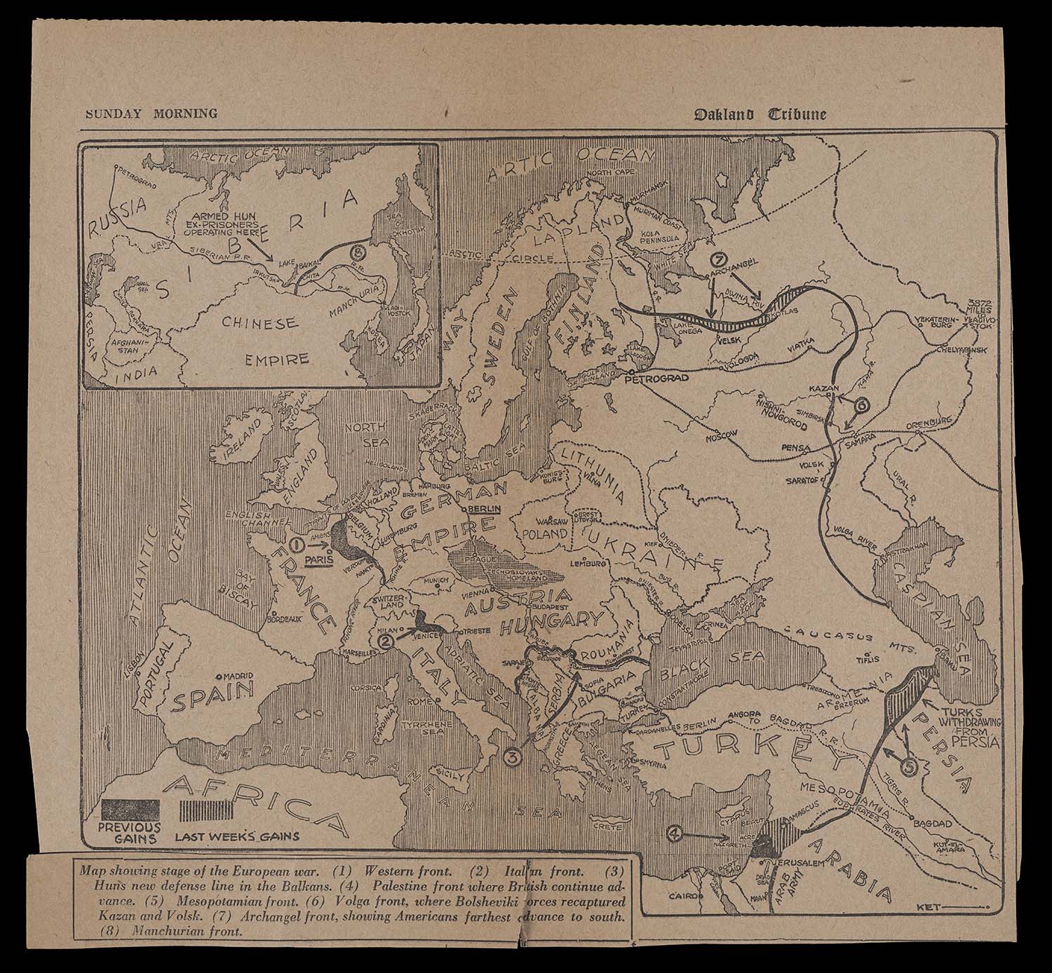
Newsmaps located on inner spreads of newspapers were typically simple and monochrome, unlike the colorful images that occupied the front-pages. This particular map, from the October 6, 1918 edition of the Oakland Tribune, depicts the geographic positions of the war's various fronts. The gains of the previous week are marked with stripes, and "previous gains" are colored black. The delineations of the Western front and the Italian front show significant previous gains, while a massive new gain is shown on the Mesopotamian front to indicate the area of Persia from which the Turks had recently withdrawn. The Eastern front appears static, unsurprising since the newly established Bolshevik government had brokered peace with the Central powers, signing the Treaty of Brest-Litovsk in March of 1918. However, recent gains are indicated on the "Archangel front," where the Allied forces were located during their intervention in the Russian Civil War. Curiously, this map also includes the Manchurian front from the Russo-Japanese War over a decade earlier.
Another significant detail on this map is the route of the Berlin-Baghdad Railway, stretching from Hamburg to Angora and marked with a thick black line intersected by short hashes. Upon reaching Angora, the projected route to Baghdad is shown as a narrow dotted line since the railroad was still 300 miles short of completion in 1918. Some scholars have argued that the Berlin-Baghdad Railway was one of many causes of the war because it gave the Germans their own shortcut to the east and undermined the leverage of the British-controlled Suez canal.
map/47694
17. Map Showing Stage of the European War
Oakland Tribune, 1918
OML Collection
URL: www.oshermaps.org/map/47694
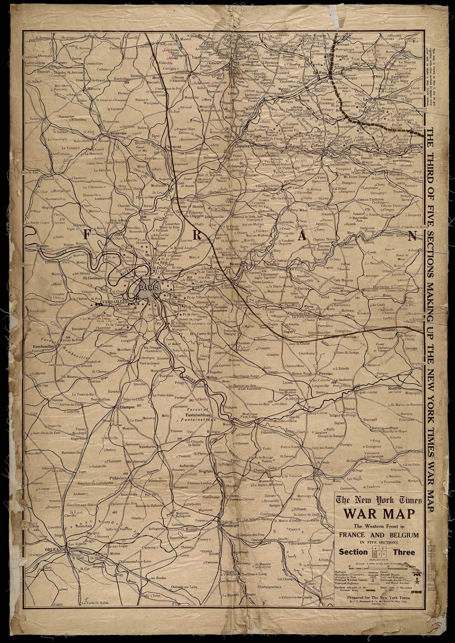
This map is one section of a large five-section map of the Western Front produced and distributed by the New York Times in early 1918. The most prominent line on the map shows the location of the battle line at the end of 1917, and the other prominent line, thinner and solid, shows how close the Germans came to Paris earlier in the war. The many fortifications around Paris are marked with stars.
The owner of this particular copy annotated it in red and blue as the war progressed, but did not label their annotations. A blue line runs along the Marne River, and a red line stretches between the December 31st battle line and the "Furthest Advance of the German Army" line, possibly marking the location of the front lines during the Noyon-Montdidier Offensive in June of 1918. Additional annotations appear in the form of blue Xs in the top right of the map, near the December 31 line. These marks may indicate the locations of camps or supply depots. For instance, one of the Xs is placed at Verneuil, where the Motor Transport Corps reconstruction park and main supply depot was located.
map/40797
18. The New York Times War Map: The Western Front in France and Belgium
New York Times, 1917
OML Collection
URL: www.oshermaps.org/map/40797
Sold throughout the United States in 1915, War Map of the Battle Ground of Liberty shows the battle lines in France and Belgium at the time of its publication. Like the New York Times map (#17), it includes the line of the German's furthest advance, which occurred in 1914. Instead of being distributed by a newspaper, this map was produced by the Rand McNally map company to be sold on its own for a reasonable twenty-five cents. Individually sold maps of war zones and events were common during World War I and could be found at a variety of locations; stores recognized that offering maps of the war front gave them a patriotic appearance.
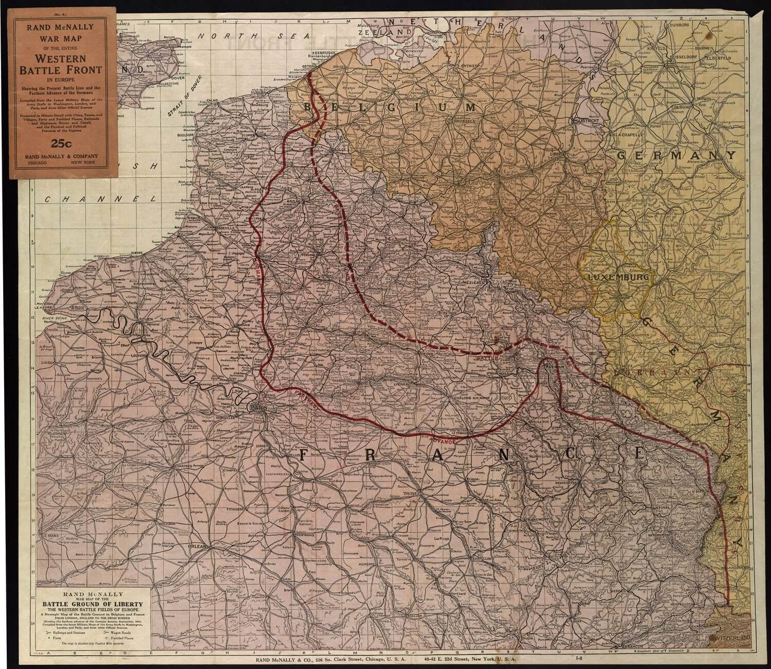
map/1413
19. Rand McNally War Map of the Battle Ground of Liberty
Rand McNally and Company, 1915
Osher Collection
URL: www.oshermaps.org/map/1413
Like the previous item (#19), this "War Map" was produced by a cartography company to be sold individually at various locations throughout the United States. Printed in 1918 by C.S. Hammond & Co., it delineates the battle line of the Italian front on September 6 with a dashed red line, which marks the furthest eastern advance of the Italian army with a solid red line. Initially, Germany and Austria-Hungary had anticipated the assistance of Italy, the third member of their Triple Alliance. Italy, however, claimed that the Alliance was intended for defense, and Austria-Hungary's instigation of the war removed any obligation for assistance. Less than a year into the war, the Allies secured Italy's support with the Treaty of London.
Unfortunately for the Italian troops, the Austro-Hungarian army had already secured the high ground of the Julian Alps and Karst Plateau at the outset of the conflict, and the Italians were unable to rout them despite outnumbering them three-to-one. While trench warfare was present on both the Western and Italian fronts, the extreme cold of the winters and high altitude made for more dangerous conditions in the trenches of the Alps. For example in December of 1916 ten thousand Italian and Austrian soldiers died from avalanches. Tunnels were constructed by both sides in an attempt to shelter their soldiers from enemy fire and the brutal cold. Living in horrendous conditions and achieving little or no gains after multiple attacks, the Italian forces suffered from low morale and saw more than one mutiny. Finally, in October 1918, the Italian army achieved a major victory against the Austrian defensive line near Sacile. On November 3, Austria-Hungary sent a flag of truce, requesting an armistice. Within weeks, Italy controlled the entire territory it had been promised in the Treaty of London.

map/1426.0002
20. Hammond's Large Scale War Map of the Italian Front
C. S. Hammond and Company, 1918
Osher Collection
URL: www.oshermaps.org/map/1426.0002
The Daily Mail and the London Geographic Institute published many maps throughout the war, beginning almost immediately after its outset. Still active today, the Daily Mail is generally considered a tabloid, but in the late 1800s and early 1900s, it was a daily newspaper with populist overtones, marketed towards the lower middle class. Not distributed in their daily paper, this map was produced by the Daily Mail to be sold on its own for the relatively low price of sixpence. The first iteration of this map was likely printed in the fall of 1914.
War Strength of the Great Powers compares the military might of the Allied forces, the Triple Entente, with the military might of the Triple Alliance, comprised of Germany, Austria-Hungary, and Italy. Despite Italy's declaration of neutrality on August 8, 1914, this map tentatively places it on the side of the Central power, highlighting its borders in green. The specific factors compared include the size of armies and navies, the number of aircrafts, and the war funds available to each country. The first graphic shows the sizes of the combatants' armed forces, with Britain's appearing pitifully small next to the armies of Russia, France, and the Central Powers. It's no surprise that the Daily Mail chose to place this graphic first; the paper argued zealously for conscription early on in the war.

map/42505
21. Daily Mail War Map
George Philip and Son, c.1915
Smith Collection
URL: www.oshermaps.org/map/42505
Produced by the Literary Digest over a year after the war had ended, this "Liberty Map" incorporates the changes brought about by the Paris Peace Conference of 1919. The base layer of the map shows the nations and borders as they existed in 1914, over which thick red borders and text indicate the newly created nations and altered borders determined by the winning powers. Several new countries were created to more accurately follow ethnic territories, including Finland, Estonia, Latvia, and Lithuania, all of which were comprised of land previously controlled by Russia. Poland was reconstituted, having been divided between Germany, Austria-Hungary, and Russia long before the war. Further south, Austria-Hungary was dissolved to create the independent nations of Austria, Hungary, Czechoslovakia, and Yugoslavia, the last of which also included territory previously ruled by the states of Montenegro and Serbia.
The inset map of Africa at top right highlights the "mandates" claimed by specific European nations. The Paris Peace Conference redefined the borders of African nations, which had already been carved up during the "Scramble for Africa" in previous decades. By 1914, 9% of Africa's population was under administration of the Germans. After the war, these German colonies were seized and divided among Britain, France, and Belgium, each of which already had an extensive colonial presence in Africa; Britain, for example, already claimed the native lands 30% of Africa's population.
The experiences of Africans in World War I are often neglected in accounts of the war; in reality, an estimated two million Africans were involved in conflict, including tens of thousands who died. Faced with forced recruitment, some resisted, including 12,000 South African troops. Another occurrence of resistance, the Volta-Bani revolt in French West Africa, morphed into an anti-colonial war in 1915 and 1916.

map/11858
22. Liberty Map of New Europe
Literary Digest, 1920
Naden Collection
URL: www.oshermaps.org/map/11858