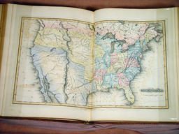
Mathew Carey’s American Atlas (see items 20-21) consolidated the practice of mapping the Republic as an assemblage of individual states. Indeed, this basic structure is still used today for atlases of the United States. However, publishers after Carey did not limit themselves to the Constitutional understanding of the Republic. Fielding Lucas, Jr., for example, prefaced his atlases with a map of the whole Union [item 23]. At the same time, hints of the Republic’s expansive nature were incorporated into these atlases; consider the ambiguous and open depiction of Mexico’s northern boundary in an 1822 atlas by Carey & Lee [item 24]. Of course, the dominant images in U.S. atlases remained those of the individual states. Lucas thus continued the practice of representing one state per page in his curious scroll-format atlas of ca. 1823 [item 25].
img/flat/map24.jpg
Fielding Lucas, Jr. (American, 1781-1854)
United States
Engraving, hand-colored, 29.5cm x 48.5cm
In: A General Atlas Containing Distinct Maps Of all the known Countries in the World. Constructed from the Latest Authority (Baltimore: Fielding Lucas, Jr., [1823]), [plate 49]
Osher Collection

img/flat/map25.jpg
Carey & Lea (American company, 1822-after 1836)
Geographical, Statistical, and Historical Map of Mexico
Letterpress and hand-colored engraving, 38.5cm x 37.5cm (map)
In: A Complete Historical, Chronological, and Geographical American Atlas (Philadelphia: H. C. Carey and I. Lea, 1822), no. 38
Smith Collection
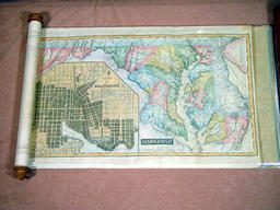
img/flat/map26.jpg
Fielding Lucas, Jr. (American, 1781-1854)
Maryland
Engraving, hand-colored, 29.0cm x 50.0cm
In: United States Atlas (Baltimore: Fielding Lucas, Jr., [ca. 1823]), [plate 12]
Osher Collection
It appears that after 1830, publishers began to combine the maps of some smaller states in their atlases of the United States as a cost-cutting measure. They generally combined the same pairs of states: New Hampshire with Vermont, Connecticut with Rhode Island, Maryland with Delaware [items 26-27]. However, this practice did not detract from the general representation of the Republic as a collection of states. A telling exception to the standard geographical practice of U.S. atlas publishers is offered by the work of Henry Schenck Tanner, who sought to rationalize the atlas-mapping of the United States. Tanner disliked the manner in which U.S. atlases fitted each state into the same size space, regardless of the state’s size; this meant, of course, that many important features in large states like New York could not be shown, while insignificant features of small states like Rhode Island received undue prominence. He therefore published atlases—in both large folio and small pocket varieties—which grouped states together on maps constructed at the same scale [items 28-29]. Because they did not conform with either of the public’s conventional understandings of how the United States was to be mapped, Tanner’s atlases were not commercial successes. Nor, for that matter, were subsequent atlases which divided up the United States along similarly rational lines.

img/flat/map27.jpg
Joseph Hutchins Colton (American, 1800-1893)
Delaware and Maryland
Engraving transferred to lithograph, hand-colored, 32.5cm x 41.0cm
In: Colton’s American Atlas (New York: J. H. Colton, [1857]), no. 22
Osher Collection

img/flat/map29.jpg
David H. Burr (American, 1803-1875)
Delaware and Mary-Land
Engraving, hand-colored, 27.0cm x 32.0cm
In: David H. Burr, A New Universal Atlas (New York: D. S. Stone, [1835]), [plate 41]
Osher Collection

img/flat/map32.jpg
Henry Schenck Tanner (American, 1786-1858)
Virginia Maryland and Delaware
Engraving, hand-colored, 51.5cm x 72.5cm
In: A New American Atlas Containing Maps of the Several States of the North American Union (Philadelphia: H. S. Tanner, 1823), [plate 15]
Osher Collection
img/flat/map33.jpg
Henry Schenck Tanner (American, 1786-1858)
Virginia Maryland and Delaware
Engraving, hand-colored, 12.5cm x 15.5cm
In: A New Pocket Atlas of the United States, with the Roads and Distances, Designed for the Use of Travellers (Philadelphia: H. S. Tanner, 1828), [plate 6]
OML Collections