The steady growth of map making through the Renaissance stimulated the collection of more detailed geographical information about areas already mapped. When Abraham Ortelius published the first modern atlas, in 1570, he devoted just one map to Spain; he was however soon able to acquire more detailed regional maps. The first of these was Geronimo de Chaves’s manuscript map of Andalusia, which was first printed in the 1579 second supplement to Ortelius’s Theatrum orbis terrarum (24).

map/26.0001
ABRAHAM ORTELIUS
Dutch, 1527-1598
HISPALENSIS CONVENTVS DELINATIO Auctore Hieronÿmo Chiaues: ANDALVZIAE PARS
From: THEATRVM ORBIS TERRARVM
Antwerp, 1579
Engraving, hand colored, 34.3 x 45.6 cm.
Nearly all the best selling atlases were, sooner or later, reduced in size to fit the pocket and pocketbook of the average reader. For example, over thirty reduced editions of Ortelius's Theatrum orbis Terrarum (1570) were published between 1577 and 1724. The small-size atlases were the "Everyman's" versions of the works of famous map makers; indeed, they were often engraved by the same craftsmen and produced by the same publishers who printed the mammoth volumes that only the wealthy could afford. These four small regional maps are all from the 1618 French edition of a pocket atlas, originally published in 1616 by Jodocus Hondius II. The atlas text was by Petrus Bertius, cosmographer to Louis XIII of France, from his Caert Thresoor of 1600, but Hondius re-engraved all the maps. A contemporary assessment of these engravings characterized them as neat, clear, and elegant.

map/38
JODOCUS HONDIUS II
Dutch, 1594-1629
a. DESCRIPTION D'ANDALVSIE. : ANDALUZIA
From: TABVLARVM GEOGRAPHICARVM . . . 1616/1618
Amsterdam, 1618 (French edition)
Engravings, ca. 9.6 x 13.6 cm.
The steady growth of geographical information allowed later publishers to devote more and more space to particular regions. Thus, Joan Blaeu could devote no less than twenty-eight maps to Spain in his twelve-volume Atlas Maior (1662); Blaeu's map of Andalusia was first published in his father's 1635 expansion of Ortelius's atlas (26).
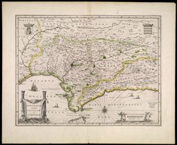
map/47
WILLEM JANSZOON BLAEU
Dutch, 1571-1638
ANDALVZIA continens SEVILLAM et CORDVBAM. 1635/1640 or later.
From: Theatrvm orbis Terrarvm
Amsterdam, JOAN BLAEU, 1640 or later.
Engraving, hand colored, 38.7 x 49.8 cm.

map/71
DOMENICO DE ROSSI
Italian, 1647-1719
LIREGNI di GRANATA è D'ANDALVCIA
Rome 1696
Engraving, 42.7 x 55.1 cm. (left half of a two-sheet map)
After 1650, the developing European economy was increasingly able to support high quality craftsmen in several regional centers. As a result, the Dutch dominance of map publishing began to wane. Our final examples of regional maps both come from Italy; both were published for the local market. The first map, the left hand portion of a large and highly detailed map of Andalusia by the Roman publisher Domenico de Rossi, published late in the seventeenth century, is engraved in a rather coarse and uncertain manner (27). In contrast, Antonio Zatta, working some eighty years later, produced an elegant and concise design, complete with an intricate title cartouche showing Andalusia's agricultural products (28).
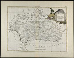
map/98
ANTONIO ZATTA
Venetian, fl. 1757-1797
ANDALUSIA e GRANADA . . .
From: ATLANTE NOVISSIMO . . . Vol. 2
Venice, 1779
Engraving, hand colored, 28.4 x 38.0 cm.