The copper printing plates used for maps generally had long lives, some remaining in use for many decades, or even centuries. Plates were edited or reworked by successive cartographers and printers as a matter of course. Some were sold or inherited, with the new owner removing his predecessor’s name and adding his own. Confusing the issue, a newly engraved copy may be almost indistinguishable from the original. It can also be difficult to determine which plate is the original, and which the copy. This section presents some examples of the problems of map identification.
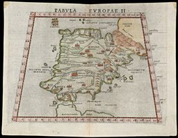
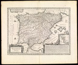
The first example is the map of Spain by Girolamo Ruscelli, published in his pocket editions of Ptolemy's Geography. The book was first printed in 1561 and was reprinted five times in the next 40 years. Each new edition featured changes to the copper plates from which the maps were printed. In fact, some of the plates were amended during the print run for the first edition. Thus, the 1561 edition is found with two versions--or "states"--of the map of Spain. We have identified no less than thirty alterations which were made to the first state of the map (37). Almost all the changes were to correct spelling mistakes (e.g., from "Telet" to "Tolet," for Toledo in the center of Spain); the engravers also added a new mountain just north of modern Gibraltar (38). We know that these maps are from the same edition of the book because they have exactly the same setting of the "type" (letters) on their reverse sides. It is certain that Ruscelli did not incorporate the corrections in an entirely new plate because the "ghosts" of the original text are still visible around the new text. Furthermore, the initial engraving of the plate included an error in, and correction of, the numbers for longitude in the lower margin: the engraver mistakenly repeated "8," but did not notice this until he reached "14," when he went back and re-engraved "9" through "15"; such an obvious mistake, and its correction, would not have been transferred from an old plate to a new plate.
map/16
GIROLAMO RUSCELLI
Venetian, ca. 1504-1566
TABVLA EVROPAE II state 1
From: LA GEOGRAFIA DI CLAVDIO TOLOMEO ALESSANDRINO, Nouamente tradotta di greco . . .
Venice, 1561
Engraving, hand colored, 18.0 x 24.8 cm.
TABVLA EVROPAE II state 2
map/37
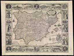
HESSEL GERRITSZ
Dutch, 1581-1652
TYPVS HISPANIÆ . . . 1613/1617
Amsterdam, JODOCUS HONDIUS II, 1617
Engraving, 35.8 x 48.9 cm., surrounded by portraits and city views
map/45
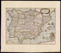
HESSEL GERRITSZ
Dutch, 1581-1652
TYPVS HISPANIÆ ab Hesselo Gerardo delineata . . . 1613/1636
From: Atlas Or A Geographicke description of the Regions, Countries and Kingdomes of the world . . .
Amsterdam, HENRICUS HONDIUS, 1636
Engraving, hand colored, 35.8 x 48.9 cm.
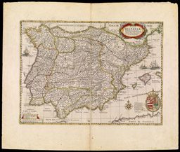
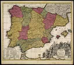
Our second example illustrates the sorts of changes--not always minor--undergone by copper printing plates as they passed through the hands of several publishers. Illustrated here are three of the seven known states of a specific map of Spain. State 1. The original map was engraved and printed by Hessel Gerritsz in 1613. State 2. In 1614, Gerritsz added an "I" to the Roman date in the cartouch at the top, to form "M.DC.XIIII" (1614). It is therefore presumed that maps were first printed from this state of the plate in 1614. State 3. The plate was acquired by the Dutch publisher Pieter van den Keere, who added his imprint and a date of 1615 to the lower left corner of the map; he did not change the date in the cartouche. It is presumed that maps were first printed from this state of the plate in 1615. State 4 (shown here as 39). Jodocus Hondius II was the next owner of the plate. He engraved over van den Keere's imprint with his own, and gave the date of 1617. If one looks carefully, the "ghost" of van den Keere's imprint can still be seen. Once again, the date in the cartouche was not altered. State 5. In the same year, 1617, Jodocus Hondius removed the illustrated border from the plate. Maps were presumably pulled from this state of the plate in 1617 and perhaps thereafter. (The problem is that this state is not found in any extant atlases, which might confirm later printings.) State 6 (shown here as 40). Jodocus Hondius's elder brother, Henricus, took control of the plate in about 1630. He once again re-engraved the imprint, with the date 1631, and an associated change in the cartouche date to read "M.DC.XXXI" (1631). To change the imprint, Henricus simply replaced his brother's first name; he did not, however, erase the "F." in Jodocus's imprint, meaning "junior" (from the Latin, filii, "son"), thus leading to some confusion. This sixth state appears in several atlases published by Henricus until 1641. State 7 (shown here as 41). Finally, the plate passed to the Hondius's brother-in-law, Johannes Janssonius. He also re-engraved the imprint but, in his usual style, deleted all dates on the map. This state is associated with atlases published from 1645 to 1658.
map/54
HESSEL GERRITSZ
Dutch, 1581-1652
TYPVS HISPANIÆ ab Hesselo Gerardo delineata . . . 1613/1652
From: Ioannis Novus Atlas, Sive Theatrum Orbis Terrarum . . . Vol. II
Amsterdam, JOHANNES JANSSONIUS, 1652
Engraving, hand colored, 35.8 x 49.2 cm.

map/28
ABRAHAM ORTELIUS
Dutch, 1527-1598
HISPANIAE VETERIS DESCRIPTIO. Ex conatibus Geographicis Abrah. Ortely.
From: Additamentum IV Theatri Orbis Terrarum
Antwerp, after 1586
Engraving, hand colored, 37.3 x 49.0 cm.
A quick glance at the two pairs of maps presented here suggests that each pair was printed from different states of the same plate. Items 42 and 43 bear a striking resemblance. The stippling of the seas on 42 suggests that it is from a heavily reworked plate; that is, 42 represents a later state. But this is not the case. The ornamentation of 42--e.g., of the cartouche and the text in the seas--is of an older style than that of 43. They are in fact examples of different "plates": Johannes Janssonius made his map (43) by copying Abraham Ortelius's map (42) very closely. The copy was made some seven decades after the original!
map/161
JOHANNES JANSSONIUS
Dutch, 1588-1664
HISPANIÆ VETERIS DESCRIPTIO. Amstelodami Aupud Joannem Janssonium
From: ACCURATISSIMA ORBIS ANTIQVI DELINEATIO
Amsterdam, GEORG HORN, 1653
Engraving, hand colored, 36.8 x 48.8 cm.
map/69
PETER SCHENK I
German, 1660-1718/19
or, PETER SCHENK II
German, before 1698-1775
Novissima et accuratissima REGNORUM HISPANIÆ et PORTUGALLIÆ, Tabula Actore P. Schenk.
From: Atlas Contractus
Amsterdam, 1695-ca. 1719
Engraving, hand colored, 47.8 x 57.9 cm.
It is not so straightforward to distinguish between items 44 and 45 so as to identify which was the copy and which the original. Unlike the previous example, there are no significant stylistic differences in the cartouches or other elements of the maps which might indicate that one map was made before the other. We do know--from differences in the portrayal of mountains and other physical features--that the maps were printed from different plates. (To change just the hills without affecting adjacent features would have required such fine work that it would have been much less expensive simply to engrave a new plate.) A solution to the problem is suggested by the dates when the respective cartographers are known to have worked. Seutter was active later than the Schenks, so that 45 is probably the copy. But even this is not certain: it is unclear whether Peter Schenk father or Peter Schenk son made item 44 (they used exactly the same imprint); if the son, then it is possible that Seutter's work was copied.

map/85.0001
MATTHAUS SEUTTER
German, 1678-1757
Novissima et accuratissima REGNORUM HISPANIÆ et PORTUGALLIÆ MAPPA GEOGRAPHICA, Cura et Sumtibus MATTHÆI SEUTTERI . . .
From: ATLAS NOVUS SIVE TABULÆ GEOGRAPHICÆ
Augsburg, ca. 1740
Engraving, hand colored, 49.3 x 57.4 cm.