
Manuscript maps — which are written (“script”) by hand (“manu”) — are generally held to precede printed maps. Historically, maps were made by hand before the introduction of printing. Technically, a map is first drafted by hand before a printing plate is prepared. The manuscript maps on display here all buck this trend. They were all made in the United States in the early 1800s and all were copied from existing printed maps. Why should someone bother to copy an existing map? Answering this question gives us some insight into the nature of cartographic culture in the early United States.
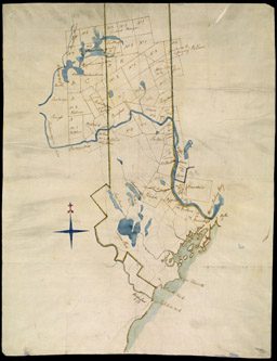
Most of these manuscript maps were made in the classroom. A standard device for learning geography in the colonial period and early Republic was to draw maps. School children were thus set the task of copying maps from any source that might come to hand, perhaps a school text, a gazetteer (57, 58), or an atlas (60, 61). The variety of sources suggests that maps were relatively rare among the general public in the early 1800s. Furthermore, although geography has always been a male preserve, girls as well as boys learned their geography by copying maps. Indeed, the teaching of geography by women school teachers also constituted a concerted female incursion into an otherwise male domain. We believe that Emily Hill was a resourceful teacher who made a manuscript wall map for her classroom. Perhaps the original printed map would have been too expensive; certainly she cobbled several pieces of expensive paper together, like a quilt, to make the whole (59). The expense and rarity of maps in the early Republic are further intimated by a map of western Maine, perhaps produced by one or more land speculators. Rather than marking up the original, precious map, the unknown businessmen copied those towns in which they were interested onto a separate map (62, 63).
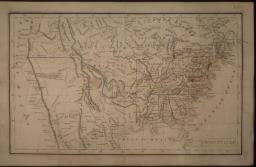
img/flat/wor33.jpg
United States
Undated manuscript, ink and water color on paper, 27 x 44cm
Gift of the Dyer Library Association
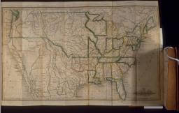
img/flat/wor34.jpg
United States
Facsimile of a copper engraving hand-colored, 25 x42.5cm
From: Jedidiah Morse and Richard C. Morse, The Traveller's Guide; or Pocket Gazetteer of the United States, 2d edition (New Haven, CT: S. Wadsworth, 1826), frontispiece
Osher Collection
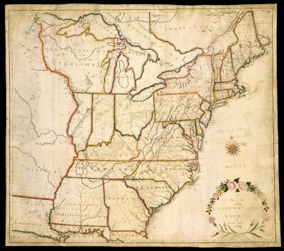
map/2398.0001
Emily Hill
American
A Map of the United States of America By Emily Hill 1820
Manuscript, ink and water color on paper, 100.5 x 115cm
Osher Collection
map/4489.0001
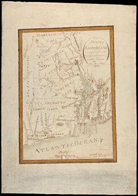
[John M. George]
American
The State of Rhode Island. Compiled from the Surveys & Observations of Caleb Harris By Hardning Harris
Manuscript (ca. 1820), ink and water color on paper, 36.5 x 26 (largest extent of irregular frame)
Smith Collection
map/4380.0046c
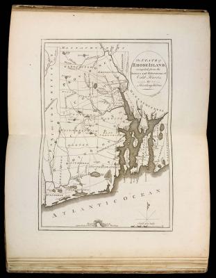
Mathew Carey
American, 1760-1839
The State of Rhode-Island; compiled, from the Surveys and Observations of Caleb Harris, By Harding Harris
Facsimile of a copper-engraving, 34.5 x 24cm
From: Carey's American Atlas: Containing Twenty Maps and One Chart (Philadelphia: Mathew Carey, 1795)
Smith Collection
map/11931
[Androscoggin Valley]
Undated manuscript, ink and water color on paper, 52.5 x 28 (largest extent)
Osher Map Library Collection
img/flat/wor39.jpg
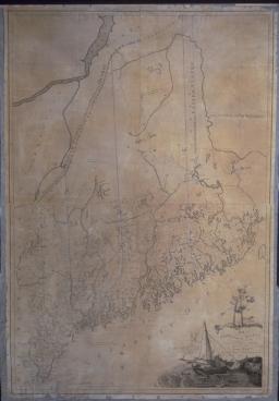
Osgood Carleton
American, 1742-1816
Map of the District of Maine Massachusetts Compiled from Actual Surveys made by Order of the General Court, and under the inspection of Agents of their appointment
Boston: B. & J. Loring, 1800
Facsimile of a detail, and a reduced facsimile of a copper-engraving, 133 x 90cm
Osher Collection