

↑ Parent: New Matthews-Northrup Global Atlas of the World at War
Collection: Naden Collection
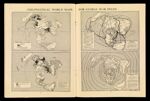
Name: Geo-Political World Maps for Global War Study
Barcode:
Image Number:
Creator:
Date Created:
Date Published:
Alternative Title: Territorial Control As of Feb 1, 1944; Density of Population; Transportation Arteries; Temperature Heat Belts
Printing Process:
Permanent URL: