


Collection: Osher Collection
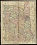
Name: Map of New Hampshire and Vermont
Barcode:
Image Number:
Creator:
From Atlas:
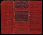
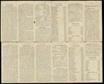
Notes: 2 maps: left and right halves-left side is Maine and right side is New Hampshire and Vermont; cover of booklet included. Verso of cover: Guide to reading the maps and the regions available in this map series. Verso of map: information regarding New Hampshire and Vermont's history, demographics, geography, etc. Note at bottom of map: "Copyright, 1891, by The Matthews-Northrup Co., Complete Engraving & Printing Works, Buffalo and New York" Plate number in lower right corner of map: "1.92".
Alternative Title:
Brief Description:
Physical Description:
Publisher:
Date/Date Range Produced:
Date/Date Range Published:
Language:
Region Depicted:
Map Type:
Dimensions: Cover: 14 x16 cm.; 2 maps: each 34 x 26 cm.
Material Type:
OCLC: 856535201
Accession Number: OS-1891-9
Donor:
Subjects:
Permanent URL: