

Collection: Osher Map Library Collection
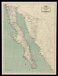
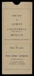
Name: Map of Lower California and the Northwestern States of Mexico : from the best available records
Barcode:
Image Number:
Creator:
Printmaker:
From Atlas:
Publishing Location:
Notes: Title on envelope: New Map of Lower California (Baja California), Mexico, showing the northwestern part of Mexico. Note: "drawn by Edward E. Knight"
Alternative Title:
Brief Description:
Physical Description:
Publisher:
Date/Date Range Produced:
Date/Date Range Published:
Language:
Region Depicted:
Map Type:
Dimensions: 87 x 66 cm. folded to 27 x 13 cm
Printing Process:
Printing Technique:
Material Type:
LC Call Number: G4475 1930 .K54 Map
OCLC: 26613033
Accession Number: OML-1930-124
Permanent URL: