

Collection: Osher Map Library Collection
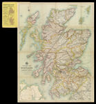
Name: Tourist's Map of Scotland Reduced by Permission from the Ordnance Survey by John Bartholomew, F.R.C.S.
Barcode:
Image Number:
Publishing Location:
Notes: Shows driving, cycling, and cart roads, bridlepaths, and steamer routes. Inset map: "Orkney and Shetland Islands." Note below neat line: "Copyright -- John Bartholomew & Co."
Date/Date Range Produced:
Date/Date Range Published:
Language:
Dimensions: 72 x56 cm folded to 20 x 11 cm
Physical Description: 1 map: colored, illustrated
OCLC: 610051272
Accession Number: OML-1914-39
Permanent URL: