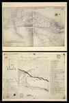
[Plate XXII] Carte d'une partie des Illinois. pour jdee seullement. A La Nouvelle orleans premier aoust 1734 Broutin[1942 copy of 1734 original]
↑ Parent: Indian Villages of the Illinois country. Part 1, Atlas
Collection:
Osher Map Library Collection
Name: [Plate XXII] Carte d'une partie des Illinois. pour jdee seullement. A La Nouvelle orleans premier aoust 1734 Broutin[1942 copy of 1734 original]
Barcode: 14437
Image Number: 14437.0029
Creator: Broutin,Courrier, J.Mercier, J. P.Tucker, Sara Jones
Date Created: 1735
Date Published: 1735
Alternative Title: [Plate XXIII] Plan de la Seigneurie et Etablissement de la mission des Tamarois [1942 copy of 1735 original]
Physical Description: Descriptive information about this facsimile can be found within the notes section of this volume which can be found from images 14437.0009 to 14437.0016
Notes: 1734 - inscribed on map; 1735 - inscribed on map
Permanent URL:
https://oshermaps.org/map/14437.0029