

Collection: French Collection
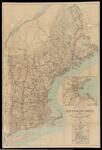
Name: Map of the New England States showing State, County and Town Boundaries
Barcode:
Image Number:
Publisher:
Date/Date Range Produced:
Date/Date Range Published:
Language:
Dimensions: 103 x 70
Notes: Oversize map mounted on cardboard. Includes 2 insets: Boston and vicinity; Providence and vicinity. Map shows administrative and political divisions
Physical Description: 1 map: color, mounted on linen
OCLC: 74717766
Accession Number: FRE-1909-53
Donor:
Permanent URL: