

Collection: Smith Collection
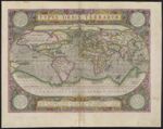
Name: Typus Orbis Terrarum
Barcode:
Image Number:
Creator:
From Atlas:
Publishing Location:
Atlas Reference:
Subjects:
Title Translation:
Brief Description:
Physical Description:
Publisher:
Date/Date Range Produced:
Date/Date Range Published:
Language:
Region Depicted:
Map Type:
Dimensions: 36 x 49 cm
Printing Process:
Printing Technique:
Material Type:
Historical Context: Abraham Ortelius?s world map was part of a bound volume of maps titled Theatrum Orbis Terrarum, [Theater of the World], now considered the first world atlas. Extending through thirty-three editions and translated into six languages, Terrarum influenced European ideas about world geography in general, and ideas about the Arctic in particular. Note the clearly defined channel above the American continent running east-west, as well as a series of Arctic channels running north-south towards the North Pole.
LC Call Number: G3200 .O7 1612
OCLC: 58437076
Accession Number: SM-1612-5
Donor:
Permanent URL: