

Collection: Smith Collection
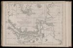
Name: A Chart of the Straits of Magellan.
Barcode:
Image Number:
Creator:
Date Published: Jul 1st, 1775
Content:
Subjects:
Full Title: A Chart of the Straits of Magellan. Inlarged from the Chart Published at Madrid in 1769, by Don Juan de la Cruz Cano y Olmedilla of the Royal Academy of St. Fernando. and Improved from the Observations and Surveys of Captains Byron, Wallis and Carteret compared with those of Monsieur de Bougainville.
Publisher:
Language:
Region Depicted:
Dimensions: Map: H 51.5 x W 68.5 cm on sheet: H 55 x W 76 cm
Printing Process:
Printing Technique:
Permanent URL: