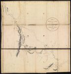
A Map of Mackenzie's Track from Fort Chipewyan to the North Sea in 1789
Collection:
Smith Collection
Name: A Map of Mackenzie's Track from Fort Chipewyan to the North Sea in 1789
Barcode: 2082
Image Number: 2082.0001
Creator: Muir Mackenzie, Alexander, Sir, 1764-1835
From Atlas: No
Notes: "Published 15 Oct. 1801"
Publisher: Muir Mackenzie, Alexander, Sir, 1764-1835
Date/Date Range Produced: 1801
Date/Date Range Published: Oct 15th, 1801
Language: English
Region Depicted: Mackenzie River Valley, Northwest TerritoriesNorthwest TerritoriesSlave River Valley, Canada
Map Type: Geographical
Dimensions: 59 x 55 cm
Printing Process: Engraving
Printing Technique: Copper
Material Type: Paper
Brief Description: Map showing the route from Fort Chipewyan, Alberta to the Arctic Ocean explored by Alexander Mackenzie in 1789, including notations of indian tribes present and river characteristics.
Physical Description: 1 map: illustrated
LC Call Number: G3466.S12 1801 .M2
OCLC: 50111922
Accession Number: SM-1801-3
Donor: Smith
Subjects: Canada, NorthernExploration and discoveryFort Chipewyan (Alta.)Indians of North AmericaLakesMackenzie River Valley (N.W.T.)Muir Mackenzie, Alexander, Sir, 1764-1835Native AmericansNorthwest TerritoriesRiversSlave River Valley (Alta. and N.W.T.)Water trails
Permanent URL:
https://oshermaps.org/map/2082.0001