

Collection: Smith Collection
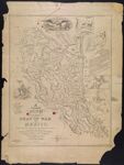
Name: A correct map of the seat of war in Mexico being a copy of Genl. Arista's map, taken at Resaca de la Palma, with additions and corrections embellished with diagrams of the battles of 8th and 9th May, and capture of Monterey, with a memorandum of forces engaged, results, &c. and plan of Vera Cruz and Castle of San Juan de Ulua designed be J.G. Bruff, Washington, D.C
Barcode:
Image Number:
Creator:
Publishing Location:
Notes: Shows portion of Mexico involved in the Battle of Monterey with historical notes cities, roads, rivers, and troop movement Note: ""Entered according to Act of Congress, in the Year 1847, by J.G. Bruff, in the Clerk's Office of the Distt. Court of the Southern Distt. of New York." Includes Table of Distances, Memorandum of the Battles of 8th & 9th May , key to symbols Explanation , Heights of Towns & Mountains, U.S. emblem of eagle on shield, and illustrated views On Stone by J. Probst. ";" Lith. of E. Jones & G.W. Newman, 128 Fulton St." Insets: Diagram of the battle ground Feb. 22d and 23d 1847 -- Plan of Monterey -- Map showing the battle grounds of the 8th and 9th May 1846 -- Chart of the Bay of Vera Cruz -- Tampico and its environs"
Date/Date Range Produced:
Date/Date Range Published:
Language:
Dimensions: 61 x 47
Printing Process:
Printing Technique:
Material Type:
Physical Description: 1 map: illustrated
LC Call Number: G4411.S44 1846 A7
OCLC: 53010686
Accession Number: SM-1847-12
Donor:
Permanent URL: