

Collection: Story Collection
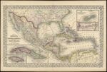
Name: Map of Mexico, Central America, and West Indies.
Barcode:
Image Number:
Creator:
Printmaker:
Publisher:
Publishing Location:
Notes: Note: "Entered according to Act of Congress in the year 1867 by S. Augustus Mitchell, Jr. in the Clerks Office of the District Court of the U.S. for the Eastern District of Pennsylvania." Insets of maps of Cuba, Jamaica, Bermuda and the Panama Railroad
Date/Date Range Produced: 1867
Language:
Dimensions: 35 x 54
Physical Description: 1 map: colored, illustrated
LC Call Number: G4410 .M5 1867
OCLC: 56625872
Accession Number: ST-1867-11
Donor:
Permanent URL: