

Collection: Osher Map Library Collection
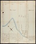
Name: Upper Checquer [River]/Middle Checquer [River].
Barcode:
Image Number:
From Atlas:
Publishing Location:
Notes: Local survey plan showing the property lines and landowners in the Saco River area, Gorham, Me., and boundary between Gorham and Waterborough, Buxton and Pepperellborough, now Saco, Me;" Title supplied by cataloger. P. Lathrop Lewis, surveyor copy examined by Daniel Sewall
Surveyor:
Date/Date Range Produced:
Date/Date Range Published:
Language:
Region Depicted:
Map Type:
Dimensions: 40 x 33 cm.
Printing Technique:
Material Type:
Brief Description:
Physical Description:
LC Call Number: G3733 .Y6 1796
OCLC: 47709851
Accession Number: OML-1796-6
Subjects:
Permanent URL: