

Collection: Osher Map Library Collection
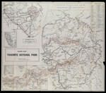
Name: Guide Map, Yosemite National Park.
Barcode:
Image Number:
Alternative Title:
Physical Description:
Publishing Location:
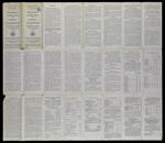
Notes: Relief shown by hachures and spot heights;" Includes distance chart, location map, Inset maps:"Map showing all routes to Yosemite National Park" "Map showing roads in Yosemite Valley" Panel title: Motorists guide map and manual, Yosemite National Park, California, 1929 Text and rate charts on verso.
Date/Date Range Produced:
Date/Date Range Published:
Language:
Dimensions: 73 x 85 cm. folded to 25 x 11 cm.
LC Call Number: G4362.Y6 1929 .U5
OCLC: 26485211
Accession Number: OML-1929-17
Permanent URL: