

Collection: Moore Collection
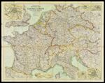
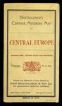
Name: Bartholomew's Motoring Map of Central Europe : showing the best touring roads with distances in kilometres
Barcode:
Image Number:
Publishing Location:
Notes: Inset maps of the cities of Vienna, Rome, Berlin, Hamburg and Paris. Includes inset of Nice and Monaco. John Bartholomew and Son Ltd. was renamed the Edinburgh Geographical Institute in 1888. Relief represented by gradient tints, hachures and spot heights.
Date/Date Range Produced:
Date/Date Range Published:
Language:
Dimensions: 74 x 95 cm. folded to 23 x 13 cm.
Physical Description: 1 map: colored, illustrated
LC Call Number: G6030.P2 B3 1937
OCLC: 84837079
Accession Number: MO-1937-25
Donor:
Permanent URL: