

Collection: Engass Collection
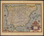
Name: Hispaniae Nova Describtio De Integro Multis In Locis, Secundum Hydrographicas, Desc. Emendata.
Barcode:
Image Number:
Creator:
Printmaker:
From Atlas:
Publishing Location:
Notes: Map of Spain engraved by Petrus Kaerius. Verso: Text in Latin.
Title Translation:
Alternative Title:
Brief Description:
Physical Description:
Publisher:
Date/Date Range Produced:
Date/Date Range Published:
Language:
Region Depicted:
Map Type:
Dimensions: 37 x 51 cm
Printing Process:
Printing Technique:
Material Type:
Historical Context: The term "atlas" derives from the books of maps produced by the famous Gerard Mercator (1512-1594), the quintessential geographer, map engraver and printer, and publisher. These books were republished posthumously in 1595 as a single work bearing the title Atlas sive Cosmographicae Meditationes. In 1604, the plates for Mercator's maps were purchased from his heirs by Jodocus Hondius (1563-1612); Hondius added new maps, such as this map of Spain, to extend the geographical coverage of Mercator's work. The Mercator-Hondius Atlas in turn spawned a host of imitators, culminating with the Blaeus' massive Atlas Major (1662).
LC Call Number: G6562 .M4 1613
OCLC: 68568863
Accession Number: ENG-1613-5
Donor:
Subjects:
Permanent URL: