

Collection: Morin Collection
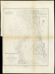
Name: Mouth of Chester River (Harbor of Refuge No.) From a Trigonometrical Survey under the direction of A. D. Bache Superintendent of the Survey of the Coast of the United States, Triangulation by J. Ferguson and K. E. Johnston Capt. Topl. Engrs. Assistants, Topography by H.L. Whiting. R. D. Cutts and J. C. Neilson Assts., Hypography by the party under the command of W. P. Mc. Arthur Lieutenant U.S. Navy
Barcode:
Image Number:
Creator:
Publishing Location:
Notes: Notes above neat line: "Harbor No." "Presented under Authority of an Act of Congress of the United States of June 3d.1884 & by direction of the Treasury Department A.D. Bache Superintendent Coast Survey." "Electrotype Copy No. 2 by G. Mathiot U.S.C.S." Includes sailing directions, tide information, other text, and U.S. Coast Survey Office insignia.
Date/Date Range Produced:
Date/Date Range Published:
Language:
Dimensions: 42 x 33
Printing Process:
Printing Technique:
Material Type:
Physical Description: 1 map
Accession Number: MOR-1849-17
Donor:
Permanent URL: