

Collection: Osher Map Library Collection
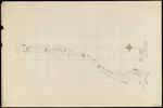
Name: [untitled map of River St. Claire; second part]
Barcode:
Image Number:
Creator:
From Atlas:
Publishing Location:
Notes: "We certify this to be a true map of part of the Boundary designated by the sixth article of the Treaty of Ghent from actual Survey by order of the Board."
Publisher:
Date/Date Range Produced:
Date/Date Range Published:
Language:
Region Depicted:
Map Type:
Dimensions: 29.5 x 54
Accession Number: OML-1891-52.16
See Also:
Donor:
Permanent URL: