

↑ Parent: Atlas Accompanying Greenleaf's Map and Statistical Survey of Maine.
Collection: Osher Map Library Collection
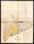
Name: Map exhibiting the principal original grants & sales of lands in the State of Maine.
Barcode:
Image Number:
Creator:
Date Created:
Date Published:
Alternative Title: Plate V.
Notes: 1829 - Copyright
Permanent URL: